IMAGES TAKEN NEAR TO
London Road, BRIGHTON, BN45 7FH
Introduction
This page details the photographs taken nearby to London Road, BN45 7FH by members of the Geograph project.
The Geograph project started in 2005 with the aim of publishing, organising and preserving representative images for every square kilometre of Great Britain, Ireland and the Isle of Man.

There are currently over 7.5m images from over14,400 individuals and you can help contribute to the project by visiting https://www.geograph.org.uk
Image Map
Images are licensed for reuse under creativecommons.org/licenses/by-sa/2.0
Notes
- Clicking on the map will re-center to the selected point.
- The higher the marker number, the further away the image location is from the centre of the postcode.
Image Listing (21 Images Found)
Images are licensed for reuse under creativecommons.org/licenses/by-sa/2.0
Image
Details
Distance
1
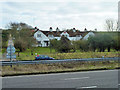
South Hill Cottages
The red rectangle on the centre gable of the block gives the date 1910 and what appears to be a crowned GR cipher. It seems unlikely royalty had anything to do with these cottages, but 1910 was the date of the accession of George V.
Image: © Robin Webster
Taken: 16 Jan 2011
0.04 miles
2
South Hill Cottages seen across the A23
See also http://www.geograph.org.uk/photo/2234288.
Image: © Shazz
Taken: 2 Jul 2016
0.05 miles
3
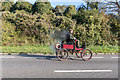
Veteran Car at London to Brighton Veteran Car Run at London Road, Brighton, East Sussex
Image: © Christine Matthews
Taken: 1 Nov 2015
0.08 miles
4
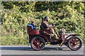
Veteran Car at London to Brighton Veteran Car Run at London Road, Brighton, East Sussex
Image: © Christine Matthews
Taken: 1 Nov 2015
0.09 miles
5
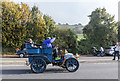
Veteran Car at London to Brighton Veteran Car Run at London Road, Brighton, East Sussex
Image: © Christine Matthews
Taken: 1 Nov 2015
0.11 miles
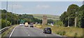
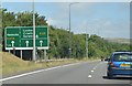
6
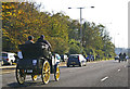
1900 Benz holding its own on the A23, Brighton Road
It's amazing how well these cars do, especially when going downhill.
Image: © Christine Matthews
Taken: 2 Nov 2008
0.12 miles
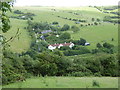
8
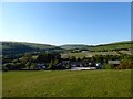
The Chestnut Stables
Viewed from open access land on Scare Hill. Christed Cottage is to the immediate left with Whitegates nearest to the A27. Rising to the right is South hill and in the distance is Wolstonbury Hill.
Image: © Simon Carey
Taken: 25 Apr 2020
0.13 miles