IMAGES TAKEN NEAR TO
Poynings Road, BRIGHTON, BN45 7BH
Introduction
This page details the photographs taken nearby to Poynings Road, BN45 7BH by members of the Geograph project.
The Geograph project started in 2005 with the aim of publishing, organising and preserving representative images for every square kilometre of Great Britain, Ireland and the Isle of Man.

There are currently over 7.5m images from over14,400 individuals and you can help contribute to the project by visiting https://www.geograph.org.uk
Image Map
Images are licensed for reuse under creativecommons.org/licenses/by-sa/2.0
Notes
- Clicking on the map will re-center to the selected point.
- The higher the marker number, the further away the image location is from the centre of the postcode.
Image Listing (53 Images Found)
Images are licensed for reuse under creativecommons.org/licenses/by-sa/2.0
Image
Details
Distance
1
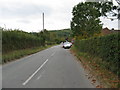
Looking south towards Poynings
The northern escarpment of Devil's Dyke is in the distance
Image: © Dave Spicer
Taken: 3 Oct 2009
0.01 miles
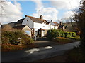
3
Mill Close
Post war housing estate built on the site of the former village allotments. Taken from Poynings Road.
Image: © Simon Carey
Taken: 7 Nov 2008
0.02 miles
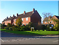
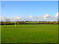
4
Two Acres
The name of the field in the foreground according to the 1840 tithe map. The fence marks Poynings Cricket Ground whilst beyond are Newtimber Hill to the right and Wolstonbury Hill in the distance.
Image: © Simon Carey
Taken: 1 Jan 2010
0.04 miles
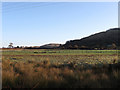
5
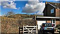
House on Poynings Road - with Newtimber Hill beyond
Image: © Ian Hawfinch
Taken: 27 Feb 2020
0.04 miles
6
Stained glass window makers
At first glance I thought this was a church hall
Image: © Dave Spicer
Taken: 3 Oct 2009
0.06 miles
7
Poynings Recreation Ground
On Poynings Road at the northern end of the village. There is also a separate cricket ground on the other side of the road.
Image: © Simon Carey
Taken: 7 Nov 2008
0.06 miles
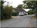
9
Drinking bowl on Poynings Road opposite Mill Lane
I didn't see a tap but presumably there had been one here.
Image: © Shazz
Taken: 19 Aug 2011
0.08 miles
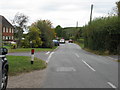
10
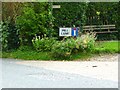
Seat at the end of Mill Lane
The road in the foreground is Cora's Walk according to Google Earth but has a sign behind the camera of Poynings Road (see http://www.geograph.org.uk/photo/2563231 ).
Image: © Shazz
Taken: 15 Aug 2011
0.08 miles