IMAGES TAKEN NEAR TO
Mill Lane, BRIGHTON, BN45 7AE
Introduction
This page details the photographs taken nearby to Mill Lane, BN45 7AE by members of the Geograph project.
The Geograph project started in 2005 with the aim of publishing, organising and preserving representative images for every square kilometre of Great Britain, Ireland and the Isle of Man.

There are currently over 7.5m images from over14,400 individuals and you can help contribute to the project by visiting https://www.geograph.org.uk
Image Map
Images are licensed for reuse under creativecommons.org/licenses/by-sa/2.0
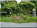
Notes
- Clicking on the map will re-center to the selected point.
- The higher the marker number, the further away the image location is from the centre of the postcode.
Image Listing (81 Images Found)
Images are licensed for reuse under creativecommons.org/licenses/by-sa/2.0
Image
Details
Distance
2
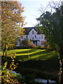
Mill House, Mill Lane
One of two mills that served the village on a small stream that ran through the village. It was still a working mill prior to the Second World War but by the 1950s had stopped working and its millpond filled in.
Image: © Simon Carey
Taken: 10 Sep 2008
0.02 miles
3
Stall in Mill Lane
On sale were eggs, jam, greeting cards and gifts.
Image: © Shazz
Taken: 15 Aug 2011
0.03 miles
4
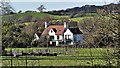
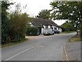
Follymead, Mill Lane
Taken from the lane with the small stream that rises to the south of the village and once powered two watermills in the foreground. The house was built in the first decade of the 20th century.
Image: © Simon Carey
Taken: 7 Nov 2008
0.03 miles
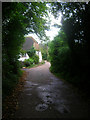
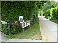
5
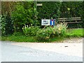
Seat at the end of Mill Lane
The road in the foreground is Cora's Walk according to Google Earth but has a sign behind the camera of Poynings Road (see http://www.geograph.org.uk/photo/2563231 ).
Image: © Shazz
Taken: 15 Aug 2011
0.05 miles
6
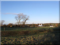
Mill Field
The name of the field according to the 1840 tithe map that has now been subdivided into a number of paddocks. Wickham House can be seen at the far end of the field.
Image: © Simon Carey
Taken: 1 Jan 2010
0.05 miles
7
Stained glass window makers
At first glance I thought this was a church hall
Image: © Dave Spicer
Taken: 3 Oct 2009
0.06 miles
8
Drinking bowl on Poynings Road opposite Mill Lane
I didn't see a tap but presumably there had been one here.
Image: © Shazz
Taken: 19 Aug 2011
0.06 miles
9
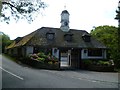
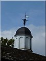
Downmere at Poynings
The clock was very wrong.
Image: © Shazz
Taken: 19 Aug 2011
0.06 miles