IMAGES TAKEN NEAR TO
Fulking Road, BRIGHTON, BN45 7AB
Introduction
This page details the photographs taken nearby to Fulking Road, BN45 7AB by members of the Geograph project.
The Geograph project started in 2005 with the aim of publishing, organising and preserving representative images for every square kilometre of Great Britain, Ireland and the Isle of Man.

There are currently over 7.5m images from over14,400 individuals and you can help contribute to the project by visiting https://www.geograph.org.uk
Image Map
Images are licensed for reuse under creativecommons.org/licenses/by-sa/2.0
Notes
- Clicking on the map will re-center to the selected point.
- The higher the marker number, the further away the image location is from the centre of the postcode.
Image Listing (19 Images Found)
Images are licensed for reuse under creativecommons.org/licenses/by-sa/2.0
Image
Details
Distance
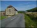
1
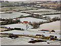
Wickhurst and Wickhurst Barn
The two structures which lie on Fulking Road below Devil's Dyke. Beyond to the left is the snow covered cricket grounds of Fulking whilst Perching Sands Farm is in the top left hand corner.
Image: © Simon Carey
Taken: 4 Feb 2009
0.02 miles
4
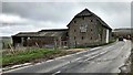
Wickhurst Barns
This was one of those days when the sea mist rolls inland from the Channel. Sometimes it just hangs over Brighton, sometimes it reaches the top of the Downs, and sometimes (like today) it puts the area just north of the Downs in shade.
Image: © Ian Hawfinch
Taken: 11 Mar 2020
0.02 miles
5
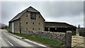
Wickhurst Barns on the way from Fulking to Poynings
Image: © Shazz
Taken: 19 Aug 2011
0.03 miles
6
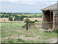
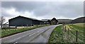
Wickhurst Barns west side and surrounding fields, Fulking
Image: © nick macneill
Taken: 30 Jun 2010
0.05 miles
7
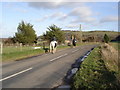
Riders on the lane between Fulking and Poynings
Image: © Ian Hawfinch
Taken: 2 Jan 2007
0.07 miles
8
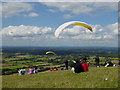
Summer pastimes on the South Downs
On fine summer Saturdays the hang-gliders and para-gliders gather to catch the rising thermals. This location, above Devil's Dyke in the South Downs, is managed by the National Trust and offers stunning views. Here you can see right across to the North Downs.
Image: © Janine Forbes
Taken: 21 Aug 2004
0.08 miles
9
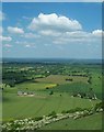
View from Devils Dyke
Looking north from Devils Dyke, across the Weald of Sussex
Image: © Graham Pritchard
Taken: Unknown
0.08 miles
10
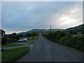
Poynings Road
Heading east out of Fulking towards Wickhurst Barn. Newtimber Hill provides the backdrop with Wolstonbury Hill just visible to the left beyond it. The early morning sun is trying to break through the cloud cover.
Image: © Simon Carey
Taken: 16 Aug 2010
0.09 miles