IMAGES TAKEN NEAR TO
Cripps Lane, STEYNING, BN44 3YD
Introduction
This page details the photographs taken nearby to Cripps Lane, BN44 3YD by members of the Geograph project.
The Geograph project started in 2005 with the aim of publishing, organising and preserving representative images for every square kilometre of Great Britain, Ireland and the Isle of Man.

There are currently over 7.5m images from over14,400 individuals and you can help contribute to the project by visiting https://www.geograph.org.uk
Image Map
Images are licensed for reuse under creativecommons.org/licenses/by-sa/2.0
Notes
- Clicking on the map will re-center to the selected point.
- The higher the marker number, the further away the image location is from the centre of the postcode.
Image Listing (341 Images Found)
Images are licensed for reuse under creativecommons.org/licenses/by-sa/2.0
Image
Details
Distance
1
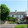
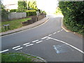
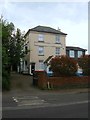
Southdown Villas, Cripps Lane, Steyning
The original name of a pair of town houses built in the 1860s not long after Steyning station was opened. These days the houses are known as South Down House, partially obscured by foliage on the left, and Silvermead to the right.
Image: © Simon Carey
Taken: 29 May 2016
0.02 miles
2
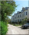
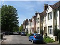
Southdown Terrace, Steyning
A cul de sac off Station Road that was built in the 1870s. The road originally ended at the Railway Hotel which was later demolished.
Image: © Simon Carey
Taken: 8 May 2016
0.02 miles
3
Station Road
Access road to the former station which was closed in 1966 with the rest of the Shoreham-Horsham line.
Image: © Simon Carey
Taken: 8 Mar 2009
0.02 miles
4
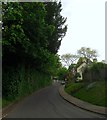
Cripps Lane, Steyning
An old highway that heads north from Jarvis Lane then becomes Vicarage Lane beyond the junction with Station Road at the foot of the slope. Beyond the church the road changes name again to Church Street.
Image: © Simon Carey
Taken: 15 May 2016
0.02 miles
5
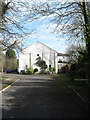
Junction Cripps Lane and Jarvis Lane
Image: © Josie Campbell
Taken: 14 Aug 2011
0.03 miles
6
Clyde Terrace, Station Road, Steyning
Built in the 1880s on the old road to the station. The terrace contains four cottages.
Image: © Simon Carey
Taken: 8 May 2016
0.03 miles
7
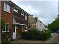
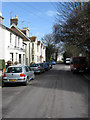
11-12, Southdown Terrace, Steyning
Along with numbers 9-10, just visible between the building in the foreground and the older Victorian terrace in the distance, built on the site of the former Railway Hotel. That was built in the 1880s and continued as public house into the 1970s, but was closed and demolished by the 1980s when these four houses were constructed.
Image: © Simon Carey
Taken: 15 May 2016
0.04 miles
8
Old Market Square, Steyning
Built on the site of Steyning station sometime in the 1980s. The station was opened in 1861, closed along with the line in 1966 and subsequently demolished in 1969. The trackbed beyond was later utilised as part of the Steyning By-Pass which opened in 1981 leading to the development of the former station site.
Image: © Simon Carey
Taken: 8 May 2016
0.05 miles
9
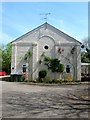
The Firs, Jarvis Lane, Steyning
Built as the Railway Inn probably in the 1860s when the Shoreham-Christ's Hospital railway was opened. It ceased being a pub in the 1930s possibly due to being in competition with the Railway Hotel which was located on the opposite side of the road and thus slightly nearer the station, see Image It has since been converted into flats with the section facing the road called The Firs and a two storey dwelling to the rear named Rose cottage which still retains some old pub advertising on its external walls.
Image: © Simon Carey
Taken: 15 May 2016
0.05 miles
10
Old Market Square
A reminder of the former market that operated on this site between 1890-1974. Originally the market had been held in the High Street but the problems caused by livestock on the main street and the opening of the railway in 1861 eventually secured a move. The building in view is a former warehouse originally built as part of the station's good yard and now the only remaining structure left to remind you that a railway station once existed on this site.
Image: © Simon Carey
Taken: 8 Mar 2009
0.05 miles