IMAGES TAKEN NEAR TO
Maudlin Lane, STEYNING, BN44 3WX
Introduction
This page details the photographs taken nearby to Maudlin Lane, BN44 3WX by members of the Geograph project.
The Geograph project started in 2005 with the aim of publishing, organising and preserving representative images for every square kilometre of Great Britain, Ireland and the Isle of Man.

There are currently over 7.5m images from over14,400 individuals and you can help contribute to the project by visiting https://www.geograph.org.uk
Image Map
Images are licensed for reuse under creativecommons.org/licenses/by-sa/2.0
Notes
- Clicking on the map will re-center to the selected point.
- The higher the marker number, the further away the image location is from the centre of the postcode.
Image Listing (43 Images Found)
Images are licensed for reuse under creativecommons.org/licenses/by-sa/2.0
Image
Details
Distance
1
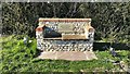
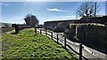
Memorial seat to the south of Maudlin Lane
This is near where the footpath joins the lane. It has a fine view to the south.
Image: © Ian Hawfinch
Taken: 23 Mar 2020
0.02 miles
2
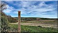
Start of footpath on the south side of Maudlin Lane
This footpath heads south to Annington Road.
Image: © Ian Hawfinch
Taken: 21 Mar 2020
0.04 miles
3
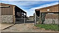
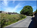
Maudlyn Farm entrance
On the 1 : 25 000 OS map 'Maudlyn' is spelt with an 'i'. I'm going by the name on the wall by the farm-gates.
Image: © Ian Hawfinch
Taken: 21 Mar 2020
0.04 miles
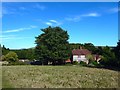
4
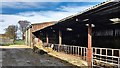
Cowshed at Maudlyn Farm
On the 1 : 25 000 OS map 'Maudlyn' is spelt with an 'i'. I'm going by the name on the wall by the farm-gates.
Image: © Ian Hawfinch
Taken: 21 Mar 2020
0.04 miles
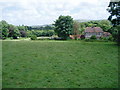
6
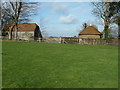
Maudlin Farm, Maudlin Lane, Bramber
The farmhouse is behind the flint wall to the right.
Image: © Simon Carey
Taken: 30 Jul 2020
0.06 miles
7
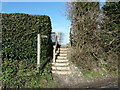
Steps on the Monarch's Way
The steps lead off Maudlin Lane.
Image: © Dave Spicer
Taken: 12 Feb 2011
0.06 miles
9
Maudlin Cottage, Maudlin Lane, Bramber
Dating from the 17th century and marked as Lower Maudlin Farm on the 1876 OS map becoming its present name by the 1898 edition.
Image: © Simon Carey
Taken: 30 Jul 2020
0.09 miles
10
The Monarch's Way passes Maudlin Cottage
The route continues along footpath 2295 towards Bramber
Image: © Peter Holmes
Taken: 5 Jul 2008
0.10 miles