IMAGES TAKEN NEAR TO
Toomey Road, STEYNING, BN44 3SD
Introduction
This page details the photographs taken nearby to Toomey Road, BN44 3SD by members of the Geograph project.
The Geograph project started in 2005 with the aim of publishing, organising and preserving representative images for every square kilometre of Great Britain, Ireland and the Isle of Man.

There are currently over 7.5m images from over14,400 individuals and you can help contribute to the project by visiting https://www.geograph.org.uk
Image Map
Images are licensed for reuse under creativecommons.org/licenses/by-sa/2.0
Notes
- Clicking on the map will re-center to the selected point.
- The higher the marker number, the further away the image location is from the centre of the postcode.
Image Listing (43 Images Found)
Images are licensed for reuse under creativecommons.org/licenses/by-sa/2.0
Image
Details
Distance
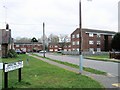
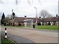
1
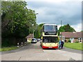
Toomey Road, Steyning
Located at the eastern end of Shooting Field and built during the 1980s after the construction of the Steyning By-Pass which is located beyond the houses on the right. this is the eastern side made up of maisoneetes and houses whereas the western side is formed of four small blocks of flats, see Image
Image: © Simon Carey
Taken: 15 May 2016
0.02 miles
2

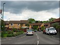
37-47, Toomey Road, Steyning
Whilst the eastern side is formed of two storey mainsonettes and houses, see Image, the western side is made up of four small blocks of flats with this one the northernmost.
Image: © Simon Carey
Taken: 15 May 2016
0.03 miles
3
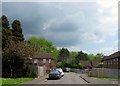
Norman Way, Steyning
A cul de sac at the southern end of Image built in the 1980s after the construction of the Steyning By-Pass which is located beyond the trees.
Image: © Simon Carey
Taken: 15 May 2016
0.05 miles
4
St Cuthman's Road, Steyning
A residential road that links Middle Mead to Shooting Field that was built in the early 1950s as part of the Shooting Field estate.
Image: © Simon Carey
Taken: 15 May 2016
0.07 miles
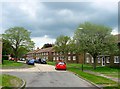
5
Shooting Field, Steyning
The cul de sac was originally eastern end of the postwar housing estate but has since been extended by the development of Image It is also the western terminus of the number 2 Brighton & Hove bus service which operates between Steyning and Rottingdean via Shoreham.
Image: © Simon Carey
Taken: 15 May 2016
0.07 miles
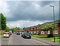
6
Farnefold Road, Steyning
Part of the housing estate built to the west of the by-pass that was developed in the mid 1980s. The road runs north from Henderson Walk becoming a cul de sac beyond the junction with Middle Mead.
Image: © Simon Carey
Taken: 15 May 2016
0.08 miles
7
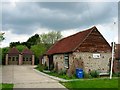
Strivens Barn, Middle Mead, Steyning
A 19th century barn that has now been converted into the local headquarters of the St John's Ambulance. Until the late 1940s the barn stood alone in open fields to the north of Steyning's urban limits. After the war the western side became part of the Shooting Field council estate though to the east it remained open fields and the barn had become part of Gatewick Farm. This lasted until the construction of the Steyning By-Pass in 1981 that cut the farm off from its fields to the east. The farm moved and the former fields to the west of the by-pass were developed as housing. At some point since then it has been converted to its current use.
Image: © Simon Carey
Taken: 15 May 2016
0.09 miles
8
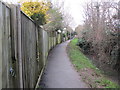
Footpath at rear of Shooting Field
Public footpath 2600.
Image: © Peter Holmes
Taken: 8 Feb 2014
0.10 miles
9
Reads Walk, Steyning
In the Shootingfields area to the North of Steyning
Image: © Paul Gillett
Taken: 3 Mar 2013
0.11 miles