IMAGES TAKEN NEAR TO
Shooting Field, STEYNING, BN44 3RX
Introduction
This page details the photographs taken nearby to Shooting Field, BN44 3RX by members of the Geograph project.
The Geograph project started in 2005 with the aim of publishing, organising and preserving representative images for every square kilometre of Great Britain, Ireland and the Isle of Man.

There are currently over 7.5m images from over14,400 individuals and you can help contribute to the project by visiting https://www.geograph.org.uk
Image Map
Images are licensed for reuse under creativecommons.org/licenses/by-sa/2.0
Notes
- Clicking on the map will re-center to the selected point.
- The higher the marker number, the further away the image location is from the centre of the postcode.
Image Listing (107 Images Found)
Images are licensed for reuse under creativecommons.org/licenses/by-sa/2.0
Image
Details
Distance
1
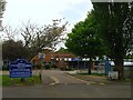
Steyning Grammar School, Shooting Field, Steyning
Opened in 1953 as Steyning Secondary Modern it amalgamated with the much older Steyning Grammar in 1968. The less photogenic of the two campuses is home to the upper school educating those from year 9 through to 13. A view of the school entrance from the public footpath.
Image: © Simon Carey
Taken: 15 May 2016
0.02 miles
2
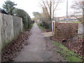
Footpath to Steyning Grammar School
Public Footpath 2600.
Image: © Peter Holmes
Taken: 8 Feb 2014
0.05 miles
3
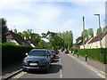
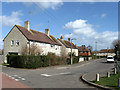
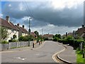
Shooting Field, Steyning
A cul de sac off the main access road also called Shooting Field that was built in the late 1940s and early 1950s. This road provides access to Steyning Grammar School's main site, St Andrew's Primary School and Steyning Town's football ground.
Image: © Simon Carey
Taken: 8 May 2016
0.06 miles
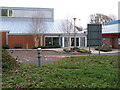
4
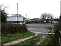
Car park at the Cuthman Centre
The Cuthman Centre is a youth wing of Steyning Grammar school.
Image: © Dave Spicer
Taken: 5 Dec 2010
0.06 miles
5
Shooting Field
Council estate built in the 1950s. This part is also the entrance to Steyning Grammar School.
Image: © Simon Carey
Taken: 8 Mar 2009
0.06 miles
6
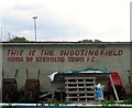
Shooting Field Football Ground, Steyning
The ground was built in the early 1950s and is home to Steyning Town FC. This is the rear of one of the covered stands on the western side of the pitch. The club formed in 1896 and operated in a number of local leagues until it joined the Sussex County League in the early 1960s. Their heyday was the mid 1980s when it won the Sussex County League title twice and reached the quarter-finals of the FA Vase.
Image: © Simon Carey
Taken: 15 May 2016
0.07 miles
7
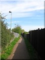
Public Footpath, Steyning
The footpath runs from Breach Close to Steyning By-Pass then continues northwards to Upper Northover Farm. This section runs between the gardens of houses in Shooting Field to the right and St Andrew's Primary School and the sports fields belonging to Steyning Grammar School to the left.
Image: © Simon Carey
Taken: 8 May 2016
0.07 miles
9
Shooting Field, Steyning
The section of the late 1940's estate that provides the entrance to the upper campus of Steyning Grammar School and Steyning Town football ground. It is also a rare opportunity to view the road without anything parked up the southern side.
Image: © Simon Carey
Taken: 2 Jul 2016
0.08 miles
10
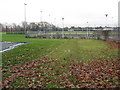
Sport pitches at Steyning Leisure Centre
Image: © Dave Spicer
Taken: 5 Dec 2010
0.08 miles