IMAGES TAKEN NEAR TO
Church Close, STEYNING, BN44 3RW
Introduction
This page details the photographs taken nearby to Church Close, BN44 3RW by members of the Geograph project.
The Geograph project started in 2005 with the aim of publishing, organising and preserving representative images for every square kilometre of Great Britain, Ireland and the Isle of Man.

There are currently over 7.5m images from over14,400 individuals and you can help contribute to the project by visiting https://www.geograph.org.uk
Image Map
Images are licensed for reuse under creativecommons.org/licenses/by-sa/2.0
Notes
- Clicking on the map will re-center to the selected point.
- The higher the marker number, the further away the image location is from the centre of the postcode.
Image Listing (110 Images Found)
Images are licensed for reuse under creativecommons.org/licenses/by-sa/2.0
Image
Details
Distance
1
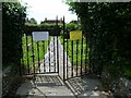
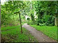
Gates to the churchyard extension at Upper Beeding
According to the notice on the left the graveyard is closed to new burials. The notice on the right is the inevitable health and safety warning.
Image: © Shazz
Taken: 24 Jun 2011
0.02 miles
2
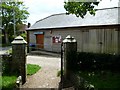
The Gladys Bevan Hall at Upper Beeding
This hall is dated 1998 and is seen here from the church path.
Image: © Shazz
Taken: 24 Jun 2011
0.02 miles
6
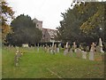
St Peter's churchyard, Sele
St Peter's is also known as the "Sele Priory Church" and was for many centuries a Benedictine Priory. It was almost completely demolished and rebuilt in 1307-1308. The tower holds 6 bells, and there is a good band of ringers. The church was an early part of Tractarianism, and under the influence of the Oxford Movement it has long stood in the "country catholic" tradition. http://www.achurchnearyou.com/upper-beeding-st-peter/
Image: © Paul Gillett
Taken: 16 Oct 2011
0.05 miles
7
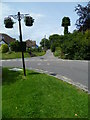
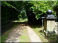
Church Lane in Upper Beeding from Deacons Way
A similar view from 2008 is at http://www.geograph.org.uk/photo/1027002. High hedges on the left have been removed since then.
Image: © Shazz
Taken: 24 Jun 2011
0.05 miles
8
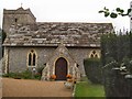
St Peter's Church, Sele
St Peter's is also known as the "Sele Priory Church" and was for many centuries a Benedictine Priory. It was almost completely demolished and rebuilt in 1307-1308. The tower holds 6 bells, and there is a good band of ringers. The church was an early part of Tractarianism, and under the influence of the Oxford Movement it has long stood in the "country catholic" tradition. http://www.achurchnearyou.com/upper-beeding-st-peter/
Image: © Paul Gillett
Taken: 16 Oct 2011
0.05 miles
9
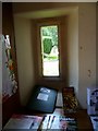
Inside the porch of the Priory Church at Upper Beeding
Image: © Shazz
Taken: 24 Jun 2011
0.05 miles
10
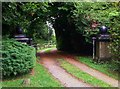
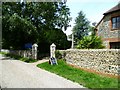
Entrance to Sele Priory, Upper Beeding
There is no longer a priory, but a house.
Image: © nick macneill
Taken: 13 Sep 2013
0.05 miles