IMAGES TAKEN NEAR TO
Maudlyn Close, STEYNING, BN44 3PQ
Introduction
This page details the photographs taken nearby to Maudlyn Close, BN44 3PQ by members of the Geograph project.
The Geograph project started in 2005 with the aim of publishing, organising and preserving representative images for every square kilometre of Great Britain, Ireland and the Isle of Man.

There are currently over 7.5m images from over14,400 individuals and you can help contribute to the project by visiting https://www.geograph.org.uk
Image Map
Images are licensed for reuse under creativecommons.org/licenses/by-sa/2.0
Notes
- Clicking on the map will re-center to the selected point.
- The higher the marker number, the further away the image location is from the centre of the postcode.
Image Listing (40 Images Found)
Images are licensed for reuse under creativecommons.org/licenses/by-sa/2.0
Image
Details
Distance
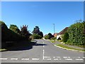
1
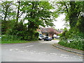
Maudlyn Close at the junction of Maudlin Lane
Image: © David Howard
Taken: 19 May 2013
0.07 miles
3
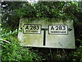
Pre-Worboys T junction map sign, Maudlin Lane
This almost slipped the system as the bushes had grown so much in the last few years it was almost invisible when I searched online, after seeing an older photo of it taken in 2006. Bramber Road is no longer the A283 as it has been bypassed and is now unclassified.
Image: © David Howard
Taken: 19 May 2013
0.10 miles
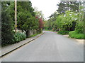
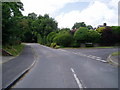
5
Maudlyn Parkway, Bramber
A cul de sac built in the 1960s in the grounds of the former Maudlin House which has now been converted into three residences.
Image: © Simon Carey
Taken: 30 Jul 2020
0.11 miles
7
The Monarch's Way on Sopers Lane
Looking west along bridleway 2292 which is now a metaled road the route passes Maudlyn Parkway.
Image: © Peter Holmes
Taken: 5 Jul 2008
0.13 miles
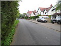
8
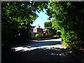
Kingsmead Lodge, Maudlin Lane, Bramber
Former lodge built in the first decade of the 20th century to serve a large house called Kingsmead whose land has since become a small cul de sac called Kingsmead Close.
Image: © Simon Carey
Taken: 30 Jul 2020
0.13 miles
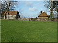
9
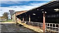
Cowshed at Maudlyn Farm
On the 1 : 25 000 OS map 'Maudlyn' is spelt with an 'i'. I'm going by the name on the wall by the farm-gates.
Image: © Ian Hawfinch
Taken: 21 Mar 2020
0.14 miles
10
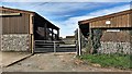
Maudlyn Farm entrance
On the 1 : 25 000 OS map 'Maudlyn' is spelt with an 'i'. I'm going by the name on the wall by the farm-gates.
Image: © Ian Hawfinch
Taken: 21 Mar 2020
0.14 miles