IMAGES TAKEN NEAR TO
Charlton Street, STEYNING, BN44 3NF
Introduction
This page details the photographs taken nearby to Charlton Street, BN44 3NF by members of the Geograph project.
The Geograph project started in 2005 with the aim of publishing, organising and preserving representative images for every square kilometre of Great Britain, Ireland and the Isle of Man.

There are currently over 7.5m images from over14,400 individuals and you can help contribute to the project by visiting https://www.geograph.org.uk
Image Map
Images are licensed for reuse under creativecommons.org/licenses/by-sa/2.0
Notes
- Clicking on the map will re-center to the selected point.
- The higher the marker number, the further away the image location is from the centre of the postcode.
Image Listing (474 Images Found)
Images are licensed for reuse under creativecommons.org/licenses/by-sa/2.0
Image
Details
Distance
1
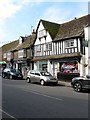
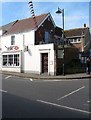
51, High Street, Steyning
A medieval timber framed house from the 15th century that has been restored with the former jettied ground floor now filled in with a shop front. Home to the Little Sweet Shop who dispense confectionery in the old fashioned way.
Image: © Simon Carey
Taken: 29 May 2016
0.01 miles
2
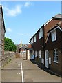
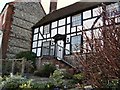
Charlton Mews, Charlton Street, Steyning
A small mews off Charlton Street that was built in the former medieval burgage plot of Image Prior to Charlton Street's construction in the mid 1800s the plots of houses on the western side of High Street backed on to common fields and often contained barns and other outbuildings, some of which still survive today. The plots of others have been built upon.
Image: © Simon Carey
Taken: 5 Jun 2016
0.01 miles
3

53, High Street, Steyning
Another Wealden hall house from the 15th century that was refaced in brick during the 18th. Currently home to HJ Burt, a local estate agent, established in 1887.
Image: © Simon Carey
Taken: 29 May 2016
0.01 miles
4
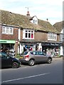
47-49, High Street, Steyning
A medieval timber framed house that has been refronted and adapted for modern commercial use. Number 47 has been home to the current occupants since 2003 whilst the neighbouring stationery shop has been operating since 2000.
Image: © Simon Carey
Taken: 29 May 2016
0.01 miles
5
43-45, High Street, Steyning
What looks like a fairly recent rebuild is home to the only supermarket chain in the town.
Image: © Simon Carey
Taken: 29 May 2016
0.01 miles
6
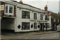
Chequer Inn, Steyning
15th century coaching inn
Image: © Stuart Johnson
Taken: 20 Sep 2016
0.02 miles
7
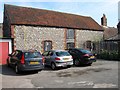
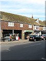
Barn, Chequers Yard, Steyning
An old flint barn to the immediate rear of the Chequers Inn, High Street. The yard contains a single business, Chalcraft, who are a builders and funeral directors, something that was very common during the 19th century but less so today. Not sure who the barn belongs to, the inn or the business.
Image: © Simon Carey
Taken: 29 May 2016
0.02 miles
8
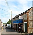
Barn, Charlton Street, Steyning
One of the features of Charlton Street is the number of former flint barns found on the eastern eside. These predate the building of the street in the 1850s and would have belonged to properties on the High Street and overlooked a large common field to the west. See also Image and Image
Image: © Simon Carey
Taken: 29 May 2016
0.02 miles
10
55, High Street, Steyning
One of two banks on the High Street, see also Image A third, Lloyds, closed its branch at Image in April 2016.
Image: © Simon Carey
Taken: 29 May 2016
0.02 miles