IMAGES TAKEN NEAR TO
Mill Road, STEYNING, BN44 3LN
Introduction
This page details the photographs taken nearby to Mill Road, BN44 3LN by members of the Geograph project.
The Geograph project started in 2005 with the aim of publishing, organising and preserving representative images for every square kilometre of Great Britain, Ireland and the Isle of Man.

There are currently over 7.5m images from over14,400 individuals and you can help contribute to the project by visiting https://www.geograph.org.uk
Image Map
Images are licensed for reuse under creativecommons.org/licenses/by-sa/2.0
Notes
- Clicking on the map will re-center to the selected point.
- The higher the marker number, the further away the image location is from the centre of the postcode.
Image Listing (201 Images Found)
Images are licensed for reuse under creativecommons.org/licenses/by-sa/2.0
Image
Details
Distance
1

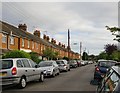
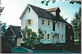
Mill Road, Steyning
The southern side of the road that connects Charlton Street and St George's Place. The terrace was constructed in the first decade of the 20th century. In the distance is Image after which the road is named.
Image: © Simon Carey
Taken: 15 May 2016
0.01 miles
2
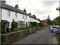
Mill Road, Steyning
Red-brick terraced housing, dating - I would guess - from about 1900. At the northern end of the street there is indeed a mill - Court Mill, an old water mill now used as a private residence.
Image: © Stefan Czapski
Taken: 25 Sep 2014
0.04 miles
3
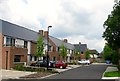
Fair Field, Steyning
A cul de sac off Charlton Street built around 2013-14 on the site of Briton's Croft, a former care home. The development is for over 55s only.
Image: © Simon Carey
Taken: 15 May 2016
0.06 miles
4
St George's Place, Steyning
The road runs from the High Street originally to Image but later Mill Road. The terrace on the left was built in 1852 for workers at the nearby tanyard, see Image, whose roof can just be made out in the distance.
Image: © Simon Carey
Taken: 15 May 2016
0.06 miles
5
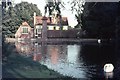
Steyning Water Mill
When this photograph was taken the public footpath passed down the length of the drive in front of the mill. The footpath has now been diverted north to pass outside the property's boundary.
Image: © Peter Jeffery
Taken: Unknown
0.06 miles
6
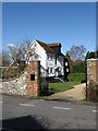
Court Mill
Former watermill parts of which date back to the 17th century. The mill was in operation until the late 1920s before being converted into a residence. A wheel dating from 1900 can still be glimpsed in the garden from a public footpath.
Image: © Simon Carey
Taken: 8 Mar 2009
0.06 miles
7
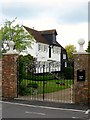
Court Mill, St George's Place, Steyning
A mill has operated here since the medieval period and was known as West Mill by the 15th century (The East Mill later became Gatweick Mill, see Image). The current building was erected in the 18th century and extended in the 19th by which time it was known as Court Mill. It remained in operation until at least 1927 though by that time it used to grind animal feed. Since then it has been converted into a residence though some of the machinery, including the 1913 waterwheel remains intact. Both building and the entrance gates are listed.
Image: © Simon Carey
Taken: 15 May 2016
0.06 miles
8

SME Ltd, Charlton Street, Steyning
A small factory located on the corner of Mill Road that was purpose built in 1961 for the company who specialise in gramophone turntables and arms.
Image: © Simon Carey
Taken: 15 May 2016
0.07 miles
9
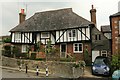
Old Workhouse, Mouse Lane
It's strange to think that this beautiful cottage used to serve as the workhouse for Steyning, from the 1770s up till the reforms on poor provision in the mid 1830s.
Image: © Stuart Johnson
Taken: 20 Sep 2016
0.07 miles