IMAGES TAKEN NEAR TO
Laines Road, STEYNING, BN44 3LL
Introduction
This page details the photographs taken nearby to Laines Road, BN44 3LL by members of the Geograph project.
The Geograph project started in 2005 with the aim of publishing, organising and preserving representative images for every square kilometre of Great Britain, Ireland and the Isle of Man.

There are currently over 7.5m images from over14,400 individuals and you can help contribute to the project by visiting https://www.geograph.org.uk
Image Map
Images are licensed for reuse under creativecommons.org/licenses/by-sa/2.0
Notes
- Clicking on the map will re-center to the selected point.
- The higher the marker number, the further away the image location is from the centre of the postcode.
Image Listing (36 Images Found)
Images are licensed for reuse under creativecommons.org/licenses/by-sa/2.0
Image
Details
Distance
1
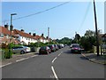
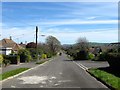
Laines Road, Steyning
A residential road that runs south from Newham Lane to Combe Road that was built in the late 1940s.
Image: © Simon Carey
Taken: 5 Jun 2016
0.04 miles
2
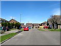
Hills Road, Steyning
A residential road that meanders between Ingram Road to the south and Newham Lane to the north that was not developed until the 1970s on the site of a former nursery thus connecting two separate residential developments.
Image: © Simon Carey
Taken: 1 May 2016
0.05 miles
3
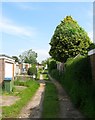
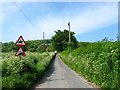
Private Track, Steyning
Running between Coombe Road and Newham Lane the track provides access for the garages to the rear of houses in Laines Road.
Image: © Simon Carey
Taken: 29 May 2016
0.05 miles
4
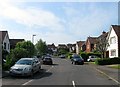
Chandlers Way, Steyning
A cul de sac off Newham Lane that was built in the 1980s.
Image: © Simon Carey
Taken: 29 May 2016
0.08 miles
5
Combe Road, Steyning
Originally laid out in the 1940s on the eastern portion of Image and accessed via Laines Road to the north. Combe Road is actually a large square with this part being the northern section. To estate to the east was not developed until the 1970s.
Image: © Simon Carey
Taken: 1 May 2016
0.08 miles
6
Coombe Road, Steyning
The opposite view of Image Laid out in the 1940s the original layout of Coombe Road was a large square accessed from the north by Laines Road. Since the 1970s a second access point has been created via Ingram Road where this is viewed from. This is the northern side, see also Image and Image
Image: © Simon Carey
Taken: 29 May 2016
0.10 miles
7

Portway, Steyning
Running south from Ingram Road where it becomes Image from this point. The road is named after the former field it was built on, part of which still survives, see Image, that was developed in the 1970s.
Image: © Simon Carey
Taken: 29 May 2016
0.11 miles
8
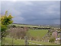
View north from Steyning bostal
Looking north from Bostal Road, as an area of rain sweeps across the Low Weald.
Image: © Stefan Czapski
Taken: 5 Apr 2016
0.13 miles
9
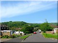
Newham Lane
Heading westwards out of Steyning towards a junction with Bostal Road on the eastern slope of Steyning Round Hill.
Image: © Simon Carey
Taken: 29 May 2016
0.13 miles
10
Sweetland, Newham Lane
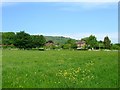
A house built in the 1950s on the outskirts of Steyning. The field in the foreground is Image
Image: © Simon Carey
Taken: 29 May 2016
0.13 miles