IMAGES TAKEN NEAR TO
The Paddocks, STEYNING, BN44 3JW
Introduction
This page details the photographs taken nearby to The Paddocks, BN44 3JW by members of the Geograph project.
The Geograph project started in 2005 with the aim of publishing, organising and preserving representative images for every square kilometre of Great Britain, Ireland and the Isle of Man.

There are currently over 7.5m images from over14,400 individuals and you can help contribute to the project by visiting https://www.geograph.org.uk
Image Map
Images are licensed for reuse under creativecommons.org/licenses/by-sa/2.0
Notes
- Clicking on the map will re-center to the selected point.
- The higher the marker number, the further away the image location is from the centre of the postcode.
Image Listing (83 Images Found)
Images are licensed for reuse under creativecommons.org/licenses/by-sa/2.0
Image
Details
Distance
1
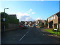
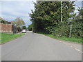
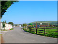
The Paddocks
Modern housing estate at the northern edge of the village. Taken from its junction with Pound Lane.
Image: © Simon Carey
Taken: 28 Oct 2008
0.02 miles
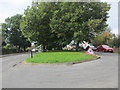
2
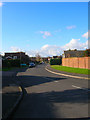
The Driftway
Modern housing estate on the northern edge of the village. Taken from its junction with Pound Lane.
Image: © Simon Carey
Taken: 28 Oct 2008
0.05 miles
5
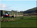
Excavator and chickens, Upper Beeding
Image: © nick macneill
Taken: 21 Dec 2012
0.10 miles
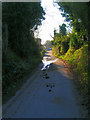
6
Footpath between roads
Pepperscoombe Lane is north of public footpath 2777, which runs between these trees whilst Deacons Way is to the South.
Image: © Peter Holmes
Taken: 28 Sep 2013
0.11 miles
7
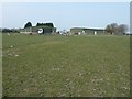
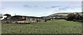
Industrial site at Newbrook Stables
At the northern end of Pound lane.
Image: © Dave Spicer
Taken: 27 Mar 2011
0.11 miles
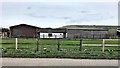
8
Newbrook Business Park, Pound Lane
Small business units next to Newbrook Farm on the left an equestrian centre that was home to the riding school for the disabled but that moved to Brinsbury College at the end of 2007. Eurocan buys and sells equipment for canning. The farm and park are built on an area once known as the Flaxlands.
Image: © Simon Carey
Taken: 27 Sep 2008
0.11 miles
9
Smugglers Lane
Taken as it approaches its junction with Pound Lane.
Image: © Simon Carey
Taken: 8 Apr 2008
0.12 miles