IMAGES TAKEN NEAR TO
Church Lane, STEYNING, BN44 3HP
Introduction
This page details the photographs taken nearby to Church Lane, BN44 3HP by members of the Geograph project.
The Geograph project started in 2005 with the aim of publishing, organising and preserving representative images for every square kilometre of Great Britain, Ireland and the Isle of Man.

There are currently over 7.5m images from over14,400 individuals and you can help contribute to the project by visiting https://www.geograph.org.uk
Image Map
Images are licensed for reuse under creativecommons.org/licenses/by-sa/2.0
Notes
- Clicking on the map will re-center to the selected point.
- The higher the marker number, the further away the image location is from the centre of the postcode.
Image Listing (156 Images Found)
Images are licensed for reuse under creativecommons.org/licenses/by-sa/2.0
Image
Details
Distance
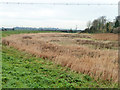
2
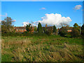
Saltings Field
A reminder that much of the Adur was once an estuary as far as Beeding and Bramber. The salt marsh was used to collect salt and there are the remains of three salterns in this field. Beyond are the houses in Priory Field.
Image: © Simon Carey
Taken: 28 Oct 2008
0.10 miles
3
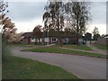
Upper Beeding Primary School
website: http://www.upperbeeding.w-sussex.sch.uk/
Image: © Paul Gillett
Taken: 16 Oct 2011
0.10 miles
5
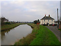
Adur House, Riverside
On the Upper Beeding side of the River Adur as it heads north into the Sussex countryside.
Image: © Simon Carey
Taken: 15 Dec 2007
0.13 miles
6
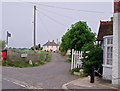
Alongside the River Adur at Upper Beeding
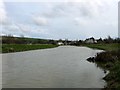
The River Adur was formerly navigable for large vessels up as far as Bramber, where there was a large port, but as the river became silted up, the port moved down to the deeper waters nearer the mouth in Shoreham-by-Sea. This was mirrored in the history of Bramber Castle - see http://www.geograph.org.uk/photo/4596648
This view looks upriver at Upper Beeding, from a road which runs parallel to the river from Beeding Bridge.
Image: © Marathon
Taken: 1 Aug 2015
0.13 miles
8
Damp area, Upper Beeding
Behind the river wall, with the River Adur out of view to the left.
Image: © Robin Webster
Taken: 15 Nov 2010
0.13 miles
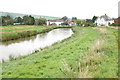
9
River Adur
Looking southwards with the houses on the right bank belonging to Millfield in Bramber and those on the left bank to Riverside, Upper Beeding.
Image: © Simon Carey
Taken: 9 Apr 2016
0.13 miles
10
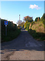
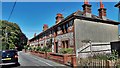
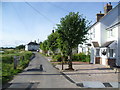
Church Lane
Prior to the building of Beeding and Bramber Bridges during the medieval period this would have been the main village street of Beeding. The village shifted southwards onto the new causeway leaving the church isolated until the 20th century when the area between the main street and church was filled in with new housing.
Image: © Simon Carey
Taken: 28 Oct 2008
0.13 miles