IMAGES TAKEN NEAR TO
Countryside Farm Park, Church Lane, STEYNING, BN44 3HF
Introduction
This page details the photographs taken nearby to Countryside Farm Park, Church Lane, BN44 3HF by members of the Geograph project.
The Geograph project started in 2005 with the aim of publishing, organising and preserving representative images for every square kilometre of Great Britain, Ireland and the Isle of Man.

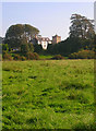
There are currently over 7.5m images from over14,400 individuals and you can help contribute to the project by visiting https://www.geograph.org.uk
Image Map
Images are licensed for reuse under creativecommons.org/licenses/by-sa/2.0
Notes
- Clicking on the map will re-center to the selected point.
- The higher the marker number, the further away the image location is from the centre of the postcode.
Image Listing (95 Images Found)
Images are licensed for reuse under creativecommons.org/licenses/by-sa/2.0
Image
Details
Distance
1
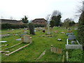
Priory Church of St Peter and St Paul: churchyard (3)
Image: © Basher Eyre
Taken: 12 Mar 2011
0.01 miles
2
Priory Church of St Peter and St Paul: churchyard (1)
Image: © Basher Eyre
Taken: 12 Mar 2011
0.05 miles
3
Church Farm Walk
Small cul-de-sac built in the 1990s off of Church Lane.
Image: © Simon Carey
Taken: 28 Oct 2008
0.07 miles
4
Priory Church of St Peter and St Paul: church hall
Image: © Basher Eyre
Taken: 12 Mar 2011
0.07 miles
5
Sele Priory
The current house still uses the name of the former priory that once stood on the site next to the church of St Peter and St Paul. The original priory was built in 1096 by William de Braose owner of nearby Bramber Castle and was inhabited by Benedictine monks from the abbey of St Florent near Saumur who retained ownership until 1396. The Benedictines left in 1459 when ownership was passed to the newly founded Magdalen College, Oxford who then allowed the Carmelites to move in 1493 after their friary in Shoreham was inundated by the sea. They began rebuilding the priory after years of neglect but were dissolved in 1538 and the building was demolished with much of the Caen stone being reused throughout the parishes of Beeding and Bramber. A vicarage was built on the site and replaced by the current building in 1792 which remained in the home of the vicar until becoming a private house in 1960. Taken from the footpath that links the footbridge at River Adur with Beeding Manor Farm.
Image: © Simon Carey
Taken: 27 Sep 2008
0.08 miles
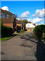
6
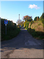
Church Lane
Prior to the building of Beeding and Bramber Bridges during the medieval period this would have been the main village street of Beeding. The village shifted southwards onto the new causeway leaving the church isolated until the 20th century when the area between the main street and church was filled in with new housing.
Image: © Simon Carey
Taken: 28 Oct 2008
0.08 miles
7
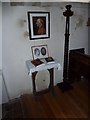
Priory Church of St Peter and St Paul: devotional area
Image: © Basher Eyre
Taken: 12 Mar 2011
0.08 miles
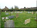
8
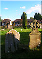
Graveyard, Priory Church of St Peter and St Paul
Taken from the door of the church looking towards the graves on the eastern side with the rear of houses in Church Farm Walk in the background.
Image: © Simon Carey
Taken: 28 Oct 2008
0.08 miles
9
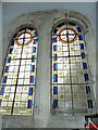
Priory Church of St Peter and St Paul: stained glass windows (2)
Image: © Basher Eyre
Taken: 12 Mar 2011
0.09 miles
10
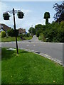
Church Lane in Upper Beeding from Deacons Way
A similar view from 2008 is at http://www.geograph.org.uk/photo/1027002. High hedges on the left have been removed since then.
Image: © Shazz
Taken: 24 Jun 2011
0.09 miles