IMAGES TAKEN NEAR TO
Sheep Pen Lane, STEYNING, BN44 3GP
Introduction
This page details the photographs taken nearby to Sheep Pen Lane, BN44 3GP by members of the Geograph project.
The Geograph project started in 2005 with the aim of publishing, organising and preserving representative images for every square kilometre of Great Britain, Ireland and the Isle of Man.

There are currently over 7.5m images from over14,400 individuals and you can help contribute to the project by visiting https://www.geograph.org.uk
Image Map
Images are licensed for reuse under creativecommons.org/licenses/by-sa/2.0
Notes
- Clicking on the map will re-center to the selected point.
- The higher the marker number, the further away the image location is from the centre of the postcode.
Image Listing (432 Images Found)
Images are licensed for reuse under creativecommons.org/licenses/by-sa/2.0
Image
Details
Distance
2
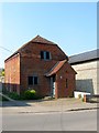
Faggs Barn, Dog Lane, Steyning
A former barn dating from the 17th century that has been converted into a residence.
Image: © Simon Carey
Taken: 1 May 2016
0.01 miles
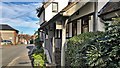
3
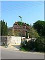
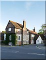
Sheep Pen Lane, Steyning
A side street linking White Horse Square to High Street. As the name suggests this was once the site of Steyning's market until it moved to a new site next to the station in 1890. The road has had various names over the centuries; Sheppenstrete during the medieval period which later became Sheep Pen Street during the 18th century. For a period of time it was called White Horse Lane after the town's major inn which lined the western side but has reverted to Sheep Pen Lane by the time of the 1971 OS map. The flint building on the right is Newham Cottage which dates back to the 18th century. Its red tiled neighbour is Barn End which was built after the Second World War. Beyond the white building contains Pen Cottage and White Horse Cottage and also dates from the 18th century.
Image: © Simon Carey
Taken: 15 May 2016
0.02 miles
5
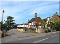
The Coach House, Sheep Pen Lane, Steyning
A former coach house that was redeveloped and converted into a residence during the early 1990s.
Image: © Simon Carey
Taken: 5 Jun 2016
0.02 miles
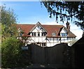
6
Newham House, Sheep Pen Lane, Steyning
Originally a timber framed house from the 15th or 16th century that was altered in the 18th and 20th centuries. The path on the right leads to Dog Lane.
Image: © Simon Carey
Taken: 5 Jun 2016
0.02 miles
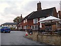
7
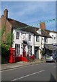
The White Horse Inn, High Street, Steyning
Steyning's main public house was first mentioned in records in 1614 but is probably older. The inn was a coaching stop and was extensively refurbished in the 18th century and was important enough to be the venue of borough court hearings, quarter sessions and important meetings. During the 19th century it was also home to the local tax office and a staging house for long distance post. In 1949 a fire ripped through the part of the building facing the street and the remains were demolished, see https://s-media-cache-ak0.pinimg.com/736x/47/88/5b/47885bb9c53f1c81f5ae77b1ff634071.jpg for an image of the pre 1949 block. Consequently the extensive stabling dating from the early 19th century at the rear of the premises was converted into new bars and guest rooms.
One of three pubs on the High Street, see also Image and Image
Image: © Simon Carey
Taken: 29 May 2016
0.02 miles
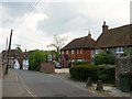
8
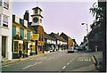
Steyning High Street, Looking South-east.
A quiet Sunday in Steyning High Street. Local transport connects it to Brighton for commuters.
Image: © Colin Smith
Taken: Unknown
0.03 miles
9
Steyning: the Stone House
At the corner where Newham Lane meets the High Street. According to Ian Nairn (writing in the Sussex volume of Pevsner's 'The Buildings of England') it was once used as the town jail.
Image: © Stefan Czapski
Taken: 30 Aug 2019
0.03 miles
10
25-27, High Street, Steyning
Number 25 on the left is home to Palace of Pooch retailing a variety of accessories for your four legged friend whilst number 27 is home to Rhubarb Cafe. Both buildings date back to the late 16th century and were originally timber framed cottages that was refronted in brick in the 18th century. The K6 phone box on the left now houses a public defibrillator and is maintained voluntarily by Palace of Pooch.
Image: © Simon Carey
Taken: 29 May 2016
0.03 miles