IMAGES TAKEN NEAR TO
Hole Street, STEYNING, BN44 3DL
Introduction
This page details the photographs taken nearby to Hole Street, BN44 3DL by members of the Geograph project.
The Geograph project started in 2005 with the aim of publishing, organising and preserving representative images for every square kilometre of Great Britain, Ireland and the Isle of Man.

There are currently over 7.5m images from over14,400 individuals and you can help contribute to the project by visiting https://www.geograph.org.uk
Image Map
Images are licensed for reuse under creativecommons.org/licenses/by-sa/2.0
Notes
- Clicking on the map will re-center to the selected point.
- The higher the marker number, the further away the image location is from the centre of the postcode.
Image Listing (58 Images Found)
Images are licensed for reuse under creativecommons.org/licenses/by-sa/2.0
Image
Details
Distance
1
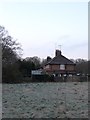
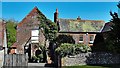
Lidbetters Cottages
Named after nearby Image and viewed from the footpath that links Hole Street to the A24.
Image: © Simon Carey
Taken: 2 Apr 2013
0.01 miles
2
Lidbetters Cottages and Crackers Cottages
Located on Hole Street at the northern end of the village of Wiston. Both are named after adjacent woods and fields, see Image and Image
Image: © Simon Carey
Taken: 27 May 2013
0.01 miles

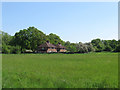
5
Wiston
Viewed from the footpath that links the village with Upper Chancton Farm. The original village was based around the church at the foot of the Downs but through the ages the population steadily migrated northwards particularly along the wasteland near the old decayed hamlet of Buncton. The last of the villagers were moved out in the 19th century when Wiston House extended its park.
Image: © Simon Carey
Taken: 2 Oct 2008
0.03 miles
6
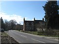
House on Hole Street
I assume this is a house?
Image: © Ian Hawfinch
Taken: 20 Apr 2020
0.05 miles
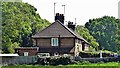
8
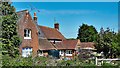
Abbots Cottages
Located on Hole Street at the northern end of the village of Wiston. These are two former labourers cottages that lie opposite Abbots Farm.
Image: © Simon Carey
Taken: 31 Mar 2013
0.05 miles
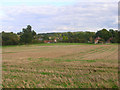
9

The Lag
The name of the field according to Wiston's 1841 tithe map viewed from Hole Street. A small unnamed stream, a tributary of the River Adur, runs through it.
Image: © Simon Carey
Taken: 20 Feb 2013
0.06 miles
10
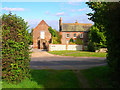
Abbots House
An 18th century farmhouse on Hole Street a minor lane linking the A283 with Ashington.
Image: © Simon Carey
Taken: 2 Oct 2008
0.06 miles