IMAGES TAKEN NEAR TO
Mouse Lane, STEYNING, BN44 3DF
Introduction
This page details the photographs taken nearby to Mouse Lane, BN44 3DF by members of the Geograph project.
The Geograph project started in 2005 with the aim of publishing, organising and preserving representative images for every square kilometre of Great Britain, Ireland and the Isle of Man.

There are currently over 7.5m images from over14,400 individuals and you can help contribute to the project by visiting https://www.geograph.org.uk
Image Map
Images are licensed for reuse under creativecommons.org/licenses/by-sa/2.0
Notes
- Clicking on the map will re-center to the selected point.
- The higher the marker number, the further away the image location is from the centre of the postcode.
Image Listing (32 Images Found)
Images are licensed for reuse under creativecommons.org/licenses/by-sa/2.0
Image
Details
Distance
1
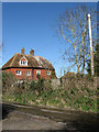
Charlton Court Cottages, Mouse Lane
Judging by the size could well have been a former farmhouse.
Image: © Simon Carey
Taken: 8 Mar 2009
0.01 miles
5
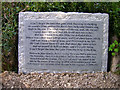
First World War memorial, Mouse Lane
Written by John Stanley Purvis whilst in the trenches and an ode to Mouse Lane which he remembered whilst waiting to go over the top. Purvis was invalided out of the war and died in 1968. Much of the surrounding area was used as an army camp during the First World War. See http://freepages.military.rootsweb.com/~thinblueline/page159.html .
Image: © Simon Carey
Taken: 9 Apr 2006
0.03 miles
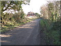
6
Junction of ways at Charlton Court
This was taken from the footpath. Ahead is the road with a bridleway just before that on the left.
Image: © Shazz
Taken: 3 Sep 2011
0.03 miles
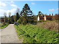
7
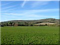
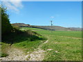
Upper Cowfield
The name of the field according to Steyning's 1840 tithe map that is bounded by Image to the east, Image to the west, Image to the north and Mouse Lane to the south. Steyning Round Hill provides the backdrop.
Image: © Simon Carey
Taken: 1 May 2016
0.05 miles
8
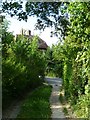
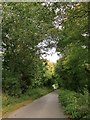
Footpath to Charlton Court
Connecting Sir George's Place with Charlton Court whilst running parallel to Mouse Lane which is beyond the trees to the right. Chanctonbury Ring is in the distance.
Image: © Simon Carey
Taken: 8 Mar 2009
0.07 miles
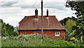
9
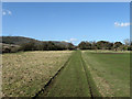
Large Grass Field Near Charlton Court Cottages
Image: © James Emmans
Taken: 2 Apr 2017
0.08 miles
10
Mouse Lane
Ahead, Mouse Lane leads gently downhill toward Steyning. Behind the camera it leads to Wiston Park http://www.geograph.org.uk/photo/3488109 where it comes to a dead end.
Image: © Stefan Czapski
Taken: 25 Sep 2014
0.08 miles