IMAGES TAKEN NEAR TO
Elm Grove Lane, STEYNING, BN44 3BS
Introduction
This page details the photographs taken nearby to Elm Grove Lane, BN44 3BS by members of the Geograph project.
The Geograph project started in 2005 with the aim of publishing, organising and preserving representative images for every square kilometre of Great Britain, Ireland and the Isle of Man.

There are currently over 7.5m images from over14,400 individuals and you can help contribute to the project by visiting https://www.geograph.org.uk
Image Map
Images are licensed for reuse under creativecommons.org/licenses/by-sa/2.0
Notes
- Clicking on the map will re-center to the selected point.
- The higher the marker number, the further away the image location is from the centre of the postcode.
Image Listing (519 Images Found)
Images are licensed for reuse under creativecommons.org/licenses/by-sa/2.0
Image
Details
Distance
2

Steyning: Cobblestone Walk
Awards proudly displayed where the passage under a shop in the High Street ends.
Image: © Michael Garlick
Taken: 2 Feb 2015
0.01 miles
4
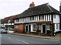
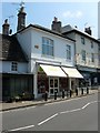
78-80, High Street, Steyning
An early 19th century three storey property whose ground floor is occupied by shops and upper floors with residential dwellings. Number 78 is an optician whilst 80 is furniture store that recycles older pieces for reuse.
Image: © Simon Carey
Taken: 29 May 2016
0.02 miles
5
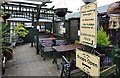
Entrance to Cobblestone Walk
Entrance to small arcade with a number of small but interesting businesses, plus the delightful Cobblestone Tea Room.
Image: © Stuart Johnson
Taken: 20 Sep 2016
0.02 miles
6
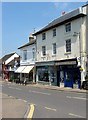
82, High Street, Steyning
One of the few non-listed buildings on the eastern side of the High Street between Church Street and Tanyard Lane. Currently occupied by Oxfam.
Image: © Simon Carey
Taken: 29 May 2016
0.02 miles
7
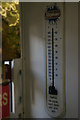
Thermometer advertising ink, Martin's newsagents, Steyning High Street
Just inside the door off the High Street.
Image: © Christopher Hilton
Taken: 24 Jan 2015
0.02 miles
8
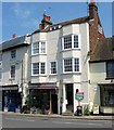
Preston House, High Street, Steyning
A three storey building from the early 19th century with the ground floor used as shop, here a small bistro, and the upper floors used for residential purposes.
Image: © Simon Carey
Taken: 29 May 2016
0.02 miles
9
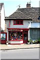
86, High Street, Steyning
Originally a single dwelling along with neighbouring Image that was built in the late medieval period as a timber framed 'L' shaped house. Currently a tattooist.
Image: © Simon Carey
Taken: 29 May 2016
0.02 miles
10
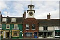
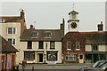
Steyning old fire station
Steyning old fire station, High Street, Steyning, West Sussex. The building has had many uses. For a while it was the Town Hall, later the Police Station and then the Fire Station. The old Fire Bell notice is still preserved on the wall. The clock was given to Steyning in 1860 by the Duke of Norfolk on the demolition of his country mansion at Michelgrove near Arundel. For more information, see http://www.steyningsouthdowns.com/bizDir/details.asp?Business=306
Image: © Kevin Hale
Taken: 28 Apr 2009
0.02 miles