IMAGES TAKEN NEAR TO
Downs View, School Lane, STEYNING, BN44 3BE
Introduction
This page details the photographs taken nearby to Downs View, School Lane, BN44 3BE by members of the Geograph project.
The Geograph project started in 2005 with the aim of publishing, organising and preserving representative images for every square kilometre of Great Britain, Ireland and the Isle of Man.

There are currently over 7.5m images from over14,400 individuals and you can help contribute to the project by visiting https://www.geograph.org.uk
Image Map
Images are licensed for reuse under creativecommons.org/licenses/by-sa/2.0
Notes
- Clicking on the map will re-center to the selected point.
- The higher the marker number, the further away the image location is from the centre of the postcode.
Image Listing (61 Images Found)
Images are licensed for reuse under creativecommons.org/licenses/by-sa/2.0
Image
Details
Distance
1
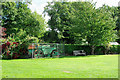
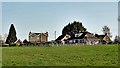
Old road-roller, Ashurst recreation ground
At the other end of the field are a cricket pavilion for Ashurst C.C. and separate slightly tatty premises labelled Ashurst F.C. The field looks like a cricket field, with no sign of a football pitch laid out, odd for late September. The field is too small for a football pitch not to encroach on a wicket area. If once the field was shared, perhaps this roller was a heavy-duty way of obtaining some sort of wicket after a winter chewing up by football.
Image: © Robin Webster
Taken: 25 Sep 2010
0.02 miles
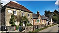
3
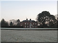
Batts
Originally an 18th century farmhouse it was completely rebuilt in the early 1960s by the then owner, Frederick Miles, the well known aircraft designer. It lies at the northern end of Image Viewed just after sunrise on a crisp frosty morning.
Image: © Simon Carey
Taken: 18 Feb 2013
0.09 miles
4
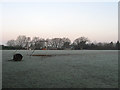
Ashurst Recreation Ground
Lying to the immediate south of School Lane and home to the village's cricket and football teams. The field was donated for recreational use in 1932 and was called Flat Field on the 1844 tithe map. Viewed at sunrise and a crisp frosty morning.
Image: © Simon Carey
Taken: 18 Feb 2013
0.09 miles
5
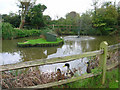
Pub Ducks, Fountain Inn
Small pond to the south of the inn is home to these ducks. Obviously used to being feed as the first thing they did when they viewed me was swim over to the fence and make plenty of noise.
Image: © Simon Carey
Taken: 28 Oct 2006
0.10 miles
6
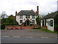
The Fountain Inn, Ashurst
18th century inn once known as the Red Lion but has been the Fountain since the 1830s. Hilaire Belloc once enjoyed some good beer here in 1902 and waxed lyrical about it, whilst in 1979 Paul McCartney filmed the video for 'Wonderful Christmastime' inside.
Image: © Simon Carey
Taken: 28 Oct 2006
0.10 miles
7
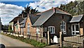
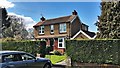
Houses around the junction of the B2135 and School Lane
Image: © Ian Hawfinch
Taken: 27 Mar 2020
0.10 miles
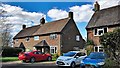
8
House near the junction between School Lane and the B2135
Image: © Ian Hawfinch
Taken: 31 Mar 2020
0.11 miles