IMAGES TAKEN NEAR TO
Peppers Lane, STEYNING, BN44 3AX
Introduction
This page details the photographs taken nearby to Peppers Lane, BN44 3AX by members of the Geograph project.
The Geograph project started in 2005 with the aim of publishing, organising and preserving representative images for every square kilometre of Great Britain, Ireland and the Isle of Man.

There are currently over 7.5m images from over14,400 individuals and you can help contribute to the project by visiting https://www.geograph.org.uk
Image Map
Images are licensed for reuse under creativecommons.org/licenses/by-sa/2.0
Notes
- Clicking on the map will re-center to the selected point.
- The higher the marker number, the further away the image location is from the centre of the postcode.
Image Listing (20 Images Found)
Images are licensed for reuse under creativecommons.org/licenses/by-sa/2.0
Image
Details
Distance
2
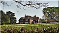
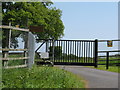
House to the south of Peppers Lane
This house is near Peppers Farm.
Image: © Ian Hawfinch
Taken: 12 Apr 2020
0.06 miles
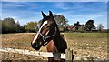
3
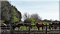
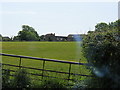
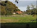
Horses to the east of Peppers Farm
The grid squares hereabouts are home to a lot of horses - that's for sure.
Image: © Ian Hawfinch
Taken: 7 Apr 2020
0.07 miles
5
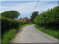
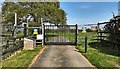
Pepper's Lane
The house is at the entrance to Pepper's Farm.
Image: © Dave Spicer
Taken: 24 May 2009
0.13 miles
7
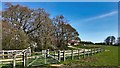
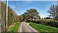
View east towards Peppers Farm
This was taken from the public footpath, which continues eastwards to the left of the trees (not along the track in the photograph).
Image: © Ian Hawfinch
Taken: 7 Apr 2020
0.16 miles