IMAGES TAKEN NEAR TO
Shooting Field, STEYNING, BN44 3AJ
Introduction
This page details the photographs taken nearby to Shooting Field, BN44 3AJ by members of the Geograph project.
The Geograph project started in 2005 with the aim of publishing, organising and preserving representative images for every square kilometre of Great Britain, Ireland and the Isle of Man.

There are currently over 7.5m images from over14,400 individuals and you can help contribute to the project by visiting https://www.geograph.org.uk
Image Map
Images are licensed for reuse under creativecommons.org/licenses/by-sa/2.0
Notes
- Clicking on the map will re-center to the selected point.
- The higher the marker number, the further away the image location is from the centre of the postcode.
Image Listing (49 Images Found)
Images are licensed for reuse under creativecommons.org/licenses/by-sa/2.0
Image
Details
Distance
1
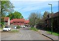
Reads Walk, Steyning
A small cul de sac off Shooting Field that was built in the last decade or so in the south west corner of Image that had been separated from the rest by the construction of Steyning By-Pass in the early 1980s. Dingemans Court is on the right.
Image: © Simon Carey
Taken: 8 May 2016
0.02 miles
2
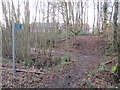
Footpath to Reads Walk
Public footpath 2600.
Image: © Peter Holmes
Taken: 8 Feb 2014
0.03 miles
4
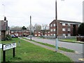
Reads Walk, Steyning
In the Shootingfields area to the North of Steyning
Image: © Paul Gillett
Taken: 3 Mar 2013
0.04 miles
5
Footbridge on route to Staplefields
Public footpath 2600.
Image: © Peter Holmes
Taken: 8 Feb 2014
0.06 miles
6
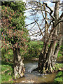
Unnamed Stream near Staplefields Farm
A tributary of the Adur that rises in Wiston Park forces its way between two trees before dropping slightly into a small pool. Next to the bridleway that links the Steyning by-pass with King's Barn Lane.
Image: © Simon Carey
Taken: 8 Mar 2009
0.09 miles
7
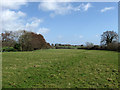
Field near Staplefields Farm
Viewed from the footpath that links the Steyning By-Pass with the farm. On the left is a small unnamed stream by which a bridleway runs towards Greenfields which can be seen in the distance.
Image: © Simon Carey
Taken: 8 Mar 2009
0.09 miles
8
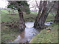
Well watered trees near Staplefieds
This tributary feeds into the River Adur 2 kilometres to the east.
Image: © Dave Spicer
Taken: 5 Dec 2010
0.09 miles
9
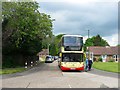
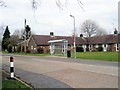
Shooting Field, Steyning
The cul de sac was originally eastern end of the postwar housing estate but has since been extended by the development of Image It is also the western terminus of the number 2 Brighton & Hove bus service which operates between Steyning and Rottingdean via Shoreham.
Image: © Simon Carey
Taken: 15 May 2016
0.10 miles
10
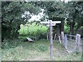
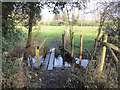
Steyning bridleway, footpath and footbridge
The footbridge crosses a small stream by this plank bridge. The bridleway heads east to Greenfields farm.
Image: © Peter Cox
Taken: 27 Sep 2007
0.10 miles