IMAGES TAKEN NEAR TO
Shirley Close, SHOREHAM-BY-SEA, BN43 6YH
Introduction
This page details the photographs taken nearby to Shirley Close, BN43 6YH by members of the Geograph project.
The Geograph project started in 2005 with the aim of publishing, organising and preserving representative images for every square kilometre of Great Britain, Ireland and the Isle of Man.

There are currently over 7.5m images from over14,400 individuals and you can help contribute to the project by visiting https://www.geograph.org.uk
Image Map
Images are licensed for reuse under creativecommons.org/licenses/by-sa/2.0
Notes
- Clicking on the map will re-center to the selected point.
- The higher the marker number, the further away the image location is from the centre of the postcode.
Image Listing (10 Images Found)
Images are licensed for reuse under creativecommons.org/licenses/by-sa/2.0
Image
Details
Distance
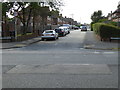
2
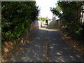
Twitten opposite side of Kingston Lane from Clarendon Road
Image: © Shazz
Taken: 29 Aug 2016
0.16 miles

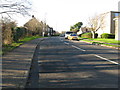
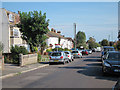
5
Junction of Rectory Road and Rectory Close
Image: © Basher Eyre
Taken: 28 Feb 2016
0.23 miles
6
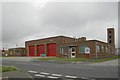
Shoreham fire station
Shoreham fire station, Stoney Lane, Shoreham-by-Sea, West Sussex
Image: © Kevin Hale
Taken: 16 Jun 2007
0.24 miles
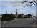
8
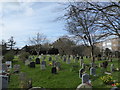
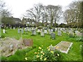
Cemetery between Rectory Road and St Julian's Lane
Image: © Basher Eyre
Taken: 28 Feb 2016
0.24 miles
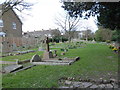
10
Kingston by Sea, churchyard
One of two yards on St. Julian's Lane, opposite Image
Image: © Mike Faherty
Taken: 7 Apr 2018
0.25 miles