IMAGES TAKEN NEAR TO
Brighton Road, SHOREHAM-BY-SEA, BN43 6RH
Introduction
This page details the photographs taken nearby to Brighton Road, BN43 6RH by members of the Geograph project.
The Geograph project started in 2005 with the aim of publishing, organising and preserving representative images for every square kilometre of Great Britain, Ireland and the Isle of Man.

There are currently over 7.5m images from over14,400 individuals and you can help contribute to the project by visiting https://www.geograph.org.uk
Image Map
Images are licensed for reuse under creativecommons.org/licenses/by-sa/2.0
Notes
- Clicking on the map will re-center to the selected point.
- The higher the marker number, the further away the image location is from the centre of the postcode.
Image Listing (153 Images Found)
Images are licensed for reuse under creativecommons.org/licenses/by-sa/2.0
Image
Details
Distance
1
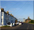
82-104, Brighton Road, Kingston By Sea
Built in the late 19th century and originally known as Pier Terrace. The building on the right is the old customs house that is now used by the scouts whilst beyond is Kingston Lighthouse.
Image: © Simon Carey
Taken: 24 May 2020
0.02 miles
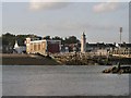
2
Kingston Lighthouse, Shoreham Harbour
See http://shoreham.adur.org.uk/lighthouse.htm and Image
I wonder what is the history of the building in the foreground.
Though not always sunny, a warm June day and the passenger in the convertible is enjoying the drive.
Image: © Chris
Taken: 11 Jun 2016
0.04 miles
3
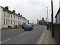
Brighton Road
Originally built in the 1780s and turnpiked in 1822. Since 1922 it has been the A259. The houses were built in the 1860s and the area around the lighthouse was known as Egypt during the 19th century. The small hut like building on the right is used by local sea cadets.
Image: © Simon Carey
Taken: 1 Feb 2009
0.04 miles
4
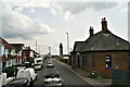
St Julians Hall, Brighton Road, Kingston By Sea
Built around the First World War as a church hall and currently in use as a co-working space for the media and advertising industry.
Image: © Simon Carey
Taken: 24 May 2020
0.05 miles
5
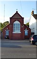
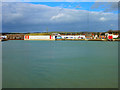
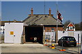
Shoreham Harbour Lifeboat Station
On the North side of the harbour, overlooking the entrance: http://www.shorehamlifeboat.co.uk/
Image: © Mike Faherty
Taken: 7 Apr 2018
0.06 miles
6
River Adur
View of the entrance to the western arm of Shoreham Harbour and the course of the Adur itself. Taken from the opposite bank north of the old fort and looking across to a mixture of industrial and leisure concerns as well as the lifeboat station on the extreme right. Behind is the mast for a BBC Boosting Station and on the horizon are the South Downs.
Image: © Simon Carey
Taken: 26 Feb 2008
0.06 miles
7
Shoreham lifeboat station and lighthouse
Seen from the beach between the sailing club and Image
Image: © Andy Potter
Taken: 6 Jul 2007
0.06 miles
8
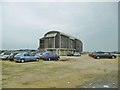
New Tamar Lifeboat Station, Shoreham-on-Sea
The building can be seen under construction here: http://www.geograph.org.uk/photo/1813366
Image: © PAUL FARMER
Taken: 13 Nov 2010
0.06 miles
9
Shoreham Harbour Lifeboat Station, Sussex
Temporary accommodation for one of the lifeboats, whilst the building of the new Lifeboat Station is completed.
Image
Image: © Peter Trimming
Taken: 17 Apr 2010
0.06 miles
10
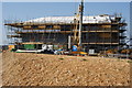
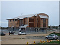
Shoreham Harbour Lifeboat Station, Sussex
The new Lifeboat Station, under construction, as at April 2010.
http://www.shorehamlifeboat.co.uk/index.html
Image: © Peter Trimming
Taken: 17 Apr 2010
0.07 miles