IMAGES TAKEN NEAR TO
Middle Road, SHOREHAM-BY-SEA, BN43 6PP
Introduction
This page details the photographs taken nearby to Middle Road, BN43 6PP by members of the Geograph project.
The Geograph project started in 2005 with the aim of publishing, organising and preserving representative images for every square kilometre of Great Britain, Ireland and the Isle of Man.

There are currently over 7.5m images from over14,400 individuals and you can help contribute to the project by visiting https://www.geograph.org.uk
Image Map
Images are licensed for reuse under creativecommons.org/licenses/by-sa/2.0
Notes
- Clicking on the map will re-center to the selected point.
- The higher the marker number, the further away the image location is from the centre of the postcode.
Image Listing (20 Images Found)
Images are licensed for reuse under creativecommons.org/licenses/by-sa/2.0
Image
Details
Distance
1
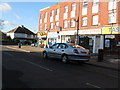
Shopping parade on Middle Road Shoreham
Image: © Dave Spicer
Taken: 29 Nov 2012
0.08 miles
2
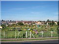
Eastern Avenue Allotments, Shoreham by Sea
Looking West from the upstairs window of no 70.
Image: © Bob Embleton
Taken: 30 Aug 2005
0.08 miles
3
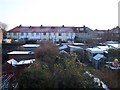
Back Gardens of Eastern Avenue and Adur Drive
After a dusting of snow, showing the ad hoc development (since the uniform layout of the post-war plots) of garden outbuildings and garages facing the "Back Lane".
Image: © Bob Embleton
Taken: 28 Dec 2005
0.09 miles
4
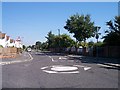
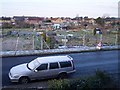
Middle Road, Hammy Lane roundabout, Kingston by Sea
Looking East along Middle road towards Brighton. Just outside Adur Social Services. Very nice people who questioned me "casing their joint!"
Image: © Bob Embleton
Taken: 30 Aug 2005
0.09 miles
5

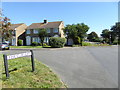
No through route
Whatever used to be the case, Nicholson Road stops here now for road vehicles. Straight on its continuation is Middle Road beyond the next crossroads. The vehicles beyond the bollards have come in the other direction and are accessing the allotments on each side of the way.
Image: © Robin Webster
Taken: 23 Mar 2010
0.10 miles
7
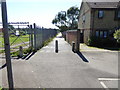
Twitten goes south from the east end of Nicolson Drive
There are allotments on the left.
Image: © Shazz
Taken: 7 Sep 2016
0.13 miles
8
Eastern Avenue Allotments with a Dusting of Snow
The cold snap just after Christmas 2005 affected the east coast including Kent.
This is the most that happened to Shoreham-by-Sea in West Sussex protected by its own micro-climate south of the South Downs.
Image: © Bob Embleton
Taken: 28 Dec 2005
0.16 miles