IMAGES TAKEN NEAR TO
Church Green, SHOREHAM-BY-SEA, BN43 6JW
Introduction
This page details the photographs taken nearby to Church Green, BN43 6JW by members of the Geograph project.
The Geograph project started in 2005 with the aim of publishing, organising and preserving representative images for every square kilometre of Great Britain, Ireland and the Isle of Man.

There are currently over 7.5m images from over14,400 individuals and you can help contribute to the project by visiting https://www.geograph.org.uk
Image Map
Images are licensed for reuse under creativecommons.org/licenses/by-sa/2.0
Notes
- Clicking on the map will re-center to the selected point.
- The higher the marker number, the further away the image location is from the centre of the postcode.
Image Listing (79 Images Found)
Images are licensed for reuse under creativecommons.org/licenses/by-sa/2.0
Image
Details
Distance
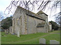
1
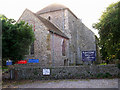
11th century church, Kingston by Sea
Looking west
Image: © Simon Carey
Taken: 1 Sep 2005
0.10 miles
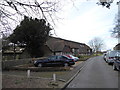
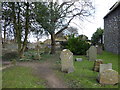
4
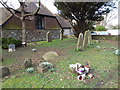
Kingston by Sea, churchyard
One of two yards on St. Julian's Lane, opposite Image
Image: © Mike Faherty
Taken: 7 Apr 2018
0.12 miles
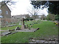
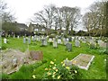
6
St Julian's Churchyard, Kingston Buci (2)
Image: © Basher Eyre
Taken: 28 Feb 2016
0.13 miles
7
St Julian's Churchyard, Kingston Buci (8)
Image: © Basher Eyre
Taken: 28 Feb 2016
0.13 miles
8
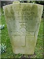
St Julian's Churchyard, Kingston Buci (3)
Also see http://www.cwgc.org/find-war-dead/casualty/402659/REDMAN,%20W%20M
Image: © Basher Eyre
Taken: 28 Feb 2016
0.13 miles
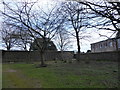
9
St Julian's Churchyard, Kingston Buci (1)
Image: © Basher Eyre
Taken: 28 Feb 2016
0.13 miles
10
St Julian, Kingston Buci: late February 2016
Image: © Basher Eyre
Taken: 28 Feb 2016
0.13 miles