IMAGES TAKEN NEAR TO
Old Shoreham Road, SHOREHAM-BY-SEA, BN43 5TE
Introduction
This page details the photographs taken nearby to Old Shoreham Road, BN43 5TE by members of the Geograph project.
The Geograph project started in 2005 with the aim of publishing, organising and preserving representative images for every square kilometre of Great Britain, Ireland and the Isle of Man.

There are currently over 7.5m images from over14,400 individuals and you can help contribute to the project by visiting https://www.geograph.org.uk
Image Map (Loading...)


Getting Data...Please wait
Leaflet Map data © OpenStreetMap
Images are licensed for reuse under creativecommons.org/licenses/by-sa/2.0
Notes
- Clicking on the map will re-center to the selected point.
- The higher the marker number, the further away the image location is from the centre of the postcode.
Image Listing (215 Images Found)
Images are licensed for reuse under creativecommons.org/licenses/by-sa/2.0
Image
Details
Distance
1

Regional Cycle Route 79
Part of new extension to Downs Link bridleway linking the route with the Adur riverside path and Shoreham's new Ropetackle development.
Image: © Peter Holmes
Taken: 8 Nov 2008
0.02 miles

3
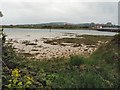
Low Tide Footpath, River Adur
Prior to the building of the extension of the Downs Link to the new Ropetackle site the best method of travelling by foot was along the edge of the river when the tide did not reach it. Still a popular though muddy route today. The old Toll Bridge and Lancing College Chapel are in the distance.
Image: © Simon Carey
Taken: 7 Dec 2008
0.07 miles
4

River Adur
Looking across to the eastern bank from the footpath that runs beside the western bank. Low tide has revealed a number of mud banks. The houses on the opposite side are in Old Shoreham Road.
Image: © Simon Carey
Taken: 18 Oct 2008
0.08 miles
5
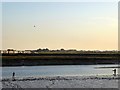
Anglers, River Adur
Taking advantage of the low tide and the late evening sun. Beyond the river to the left are hangars belonging to Shoreham Airport whilst in the distance to the right is Brighton & Hove Albion's training ground.
Image: © Simon Carey
Taken: 25 May 2020
0.09 miles
6

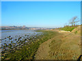
River Adur
Taken at low tide from the Old Toll Bridge with the railway bridge in the distance. See Image for a similar view taken at high tide.
Image: © Simon Carey
Taken: 18 Oct 2008
0.10 miles
7

River Adur at Shoreham
Viewed from the Downs Link path looking towards Shoreham (Brighton City) Airport
Image: © Paul Gillett
Taken: 25 Jul 2013
0.10 miles