IMAGES TAKEN NEAR TO
Hardy Close, SHOREHAM-BY-SEA, BN43 5SA
Introduction
This page details the photographs taken nearby to Hardy Close, BN43 5SA by members of the Geograph project.
The Geograph project started in 2005 with the aim of publishing, organising and preserving representative images for every square kilometre of Great Britain, Ireland and the Isle of Man.

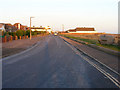
There are currently over 7.5m images from over14,400 individuals and you can help contribute to the project by visiting https://www.geograph.org.uk
Image Map
Images are licensed for reuse under creativecommons.org/licenses/by-sa/2.0
Notes
- Clicking on the map will re-center to the selected point.
- The higher the marker number, the further away the image location is from the centre of the postcode.
Image Listing (261 Images Found)
Images are licensed for reuse under creativecommons.org/licenses/by-sa/2.0
Image
Details
Distance
2
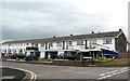
Beach Road and Atlantic Court
Houses on Beach Road with Atlantic Court on Ferry Road on the right, viewed from the beach. Atlantic Court is first shown on the 1968 1:10560 map with the area now occupied by the other buildings in this photo shown as undeveloped.
Image: © Ian Capper
Taken: 17 Mar 2022
0.05 miles
3
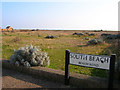
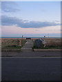
South Beach
Small piece of shingle between Beach Road and the beach itself.
Image: © Simon Carey
Taken: 15 Feb 2008
0.06 miles
5
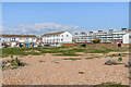
Beach Road
Shoreham Beach one side and houses on the other. The flats reflecting the evening sun are Atlantic Court.
Image: © Simon Carey
Taken: 7 Mar 2008
0.07 miles
6
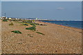
Shoreham Beach
Viewed from Beach Road which runs next to the shingle beach at this point. The settlement of the same name has been built on a shingle spit that once extended as far as Hove.
Image: © Simon Carey
Taken: 29 Mar 2009
0.08 miles
7
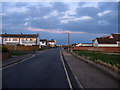
Beach Road
The greenery to the right marks an entrance point to the shingle beach whilst the road on the left is Weald Dyke. The windows of the houses are reflecting the light from the sunset.
Image: © Simon Carey
Taken: 29 Mar 2009
0.08 miles
8
24 Beach Road
The rear of 24 Beach Road as seen from the beach. Note what would appear to be an astronomical observatory on the roof.
Image: © Ian Capper
Taken: 17 Mar 2022
0.08 miles
9
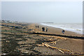
Washed up timber, Shoreham Beach
The "Ice Prince" was wrecked off Devon a few days earlier and lost its deck cargo of 2000 tonnes of timber. A lot of this ended up along the beaches of Sussex.
Image: © Robin Webster
Taken: 20 Jan 2008
0.08 miles
10
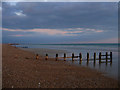
Groynes, Shoreham Beach
Taken at sunset and low tide with the latter revealing the sand that sits at the bottom of the shingle beach. The Western Breakwater that protects the mouth of Shoreham Harbour can be seen in the distance.
Image: © Simon Carey
Taken: 29 Mar 2009
0.09 miles