IMAGES TAKEN NEAR TO
Old Fort Road, SHOREHAM-BY-SEA, BN43 5RJ
Introduction
This page details the photographs taken nearby to Old Fort Road, BN43 5RJ by members of the Geograph project.
The Geograph project started in 2005 with the aim of publishing, organising and preserving representative images for every square kilometre of Great Britain, Ireland and the Isle of Man.

There are currently over 7.5m images from over14,400 individuals and you can help contribute to the project by visiting https://www.geograph.org.uk
Image Map
Images are licensed for reuse under creativecommons.org/licenses/by-sa/2.0
Notes
- Clicking on the map will re-center to the selected point.
- The higher the marker number, the further away the image location is from the centre of the postcode.
Image Listing (98 Images Found)
Images are licensed for reuse under creativecommons.org/licenses/by-sa/2.0
Image
Details
Distance
1
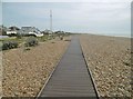
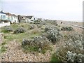
Shoreham Beach, boardwalk
Along the shingle spit towards Old Fort.
Image: © Mike Faherty
Taken: 7 Apr 2018
0.02 miles
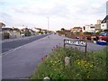
2
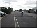
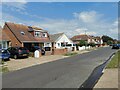
Cyclist on Old Fort Road
Approaching Compass bus stop for service 19 to Holmbush Centre, Shoreham.
Image: © Peter Holmes
Taken: 31 Aug 2013
0.03 miles
3
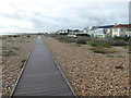
The boardwalk on Shoreham Beach
Shoreham Beach became a Local Nature Reserve in 2006 because of its habitat of vegetated shingle. A Friends of Shoreham Beach was set up to help conserve and protect this environment and raise public awareness. Their information board can be seen at http://www.geograph.org.uk/photo/5556463
Image: © Marathon
Taken: 30 Sep 2017
0.03 miles
4
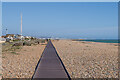
Boardwalk
Boadwalk along the beach at Shoreham Beach, with the rear of houses on Old Fort Road on the left. Behind them is the chimney of Shoreham Power Station and in the distance is Brighton.
Image: © Ian Capper
Taken: 17 Mar 2022
0.04 miles
5
Shoreham Beach
Vegetated shingle beach and designated local nature reserve: http://www.shoreham-port.co.uk/write/Coastal_Geography_2014-15.pdf
Image: © Mike Faherty
Taken: 7 Apr 2018
0.05 miles
6
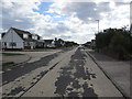
The Meadway
A Shoreham-by-sea street close to the sea. Some interesting bungalows with very few original from the 1910's left.
Image: © James Emmans
Taken: 4 Jun 2022
0.07 miles
7

Shoreham Beach at Sunset
Taken at low tide with the sand exposed below the shingle beach. The silhouetted outline of Worthing can be seen in the distance.
Image: © Simon Carey
Taken: 29 Mar 2009
0.07 miles
8
The Meadway
At junction with Cheal Close.
Image: © Peter Holmes
Taken: 31 Aug 2013
0.07 miles
9
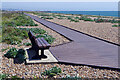
Shoreham Beach - boardwalk
At intervals along the boardwalk across Shoreham Beach benches are provided - excellent spots to relax and stare out to sea.
Image: © Stephen McKay
Taken: 16 Aug 2023
0.08 miles
10
Old Fort Road, Shoreham Beach
The seaward of two near parallel roads running west to east along the Shingle bank called Shoreham Beach. This bank has grown eastwards towards Brighton over the last 1000 years and has been occupied for about 100 years. The road leads to the mid 19th century fort protecting the harbour.
Image: © Bob Embleton
Taken: 31 May 2006
0.10 miles