IMAGES TAKEN NEAR TO
The Marlinespike, SHOREHAM-BY-SEA, BN43 5RD
Introduction
This page details the photographs taken nearby to The Marlinespike, BN43 5RD by members of the Geograph project.
The Geograph project started in 2005 with the aim of publishing, organising and preserving representative images for every square kilometre of Great Britain, Ireland and the Isle of Man.

There are currently over 7.5m images from over14,400 individuals and you can help contribute to the project by visiting https://www.geograph.org.uk
Image Map
Images are licensed for reuse under creativecommons.org/licenses/by-sa/2.0
Notes
- Clicking on the map will re-center to the selected point.
- The higher the marker number, the further away the image location is from the centre of the postcode.
Image Listing (94 Images Found)
Images are licensed for reuse under creativecommons.org/licenses/by-sa/2.0
Image
Details
Distance
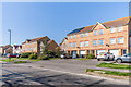
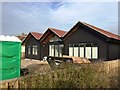
1
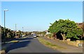
The Marlinspike, Shoreham Beach
Residential road linking Shingle Road to Winterton Way.
Image: © Simon Carey
Taken: 19 May 2020
0.02 miles
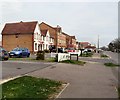
3
11 - 27 Harbour Way
One block in a group of terraces, nos 1 - 65 Harbour Way, built in 1999.
Image: © Ian Capper
Taken: 17 Mar 2022
0.05 miles
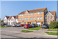
4
Anchor Close
Cul-de-sac off Harbour Way, with Waters Edge, a 2001 apartment block, in the background.
Image: © Ian Capper
Taken: 17 Mar 2022
0.05 miles
5
Harbour Way
Part of a group of terraces, nos 1 - 65 Harbour Way, built in 1999.
Image: © Ian Capper
Taken: 17 Mar 2022
0.05 miles
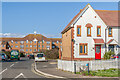
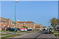
6
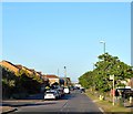
Harbour Way, Shoreham Beach
Residential road linking Riverside Road to Old Fort Road.
Image: © Simon Carey
Taken: 19 May 2020
0.05 miles
7
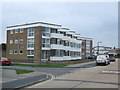
Beach Court, Shoreham Beach
Beach Court, a low-rise block of apartments by the south coast.
Image: © Malc McDonald
Taken: 5 Mar 2011
0.09 miles
8
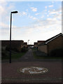
Footpath to Harbour Way
Linking the waterfront walk through Anchor Close to Harbour Way. Much of this land was redeveloped in the 1990s from former timber yards.
Image: © Simon Carey
Taken: 29 Mar 2009
0.09 miles
10
Harbour Way
Looking along Harbour Way. The buildings on the left were built in the late 20th/early 21st Century on land formerly in industrial use.
Image: © Ian Capper
Taken: 17 Mar 2022
0.11 miles