IMAGES TAKEN NEAR TO
Little High Street, SHOREHAM-BY-SEA, BN43 5PY
Introduction
This page details the photographs taken nearby to Little High Street, BN43 5PY by members of the Geograph project.
The Geograph project started in 2005 with the aim of publishing, organising and preserving representative images for every square kilometre of Great Britain, Ireland and the Isle of Man.

There are currently over 7.5m images from over14,400 individuals and you can help contribute to the project by visiting https://www.geograph.org.uk
Image Map
Images are licensed for reuse under creativecommons.org/licenses/by-sa/2.0
Notes
- Clicking on the map will re-center to the selected point.
- The higher the marker number, the further away the image location is from the centre of the postcode.
Image Listing (437 Images Found)
Images are licensed for reuse under creativecommons.org/licenses/by-sa/2.0
Image
Details
Distance
3
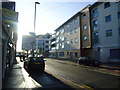
Ropetackle
Part of the Adur waterfront that has recently been redeveloped. Previously it had been the site of a gasworks, sewage works and a council depot.
Image: © Simon Carey
Taken: 15 Feb 2008
0.02 miles
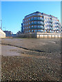
5
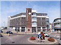
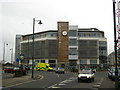
Ropetackle
Ropetackle Building 22/07/13
Image: © Andy Horton
Taken: 22 Jul 2013
0.03 miles
6
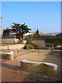
Eastern Side of Norfolk Bridge
The seats belong to the recent Ropetackle development. The lights on the bridge date from 1923 when a new bridge was constructed to replace the original 19th century suspension bridge which in turn was widened and renewed in 1970. The white building to the left is the original bridge toll house which collected tolls until 1927. On the far left is the Bridge Inn, built in the 1920s to replace an older inn on the site.
Image: © Simon Carey
Taken: 15 Feb 2008
0.03 miles
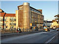
7
The Ropetackle
The Ropetackle is a new development on the east bank of the River Adur.
Image: © Peter Jeffery
Taken: Unknown
0.03 miles
8
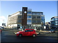
Basepoint business centre, Shoreham
Office accommodation with shared general facilities.
Image: © Robin Webster
Taken: 21 Jan 2023
0.03 miles
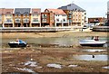
9
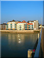
Little High Street Hard
Access point to the river for the public from the road. Viewed from the shingle bank that is exposed at low tides. The flats on the right belong to the Ropetackle development.
Image: © Simon Carey
Taken: 7 Dec 2008
0.04 miles
10
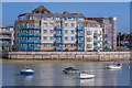
Marline Court
Part of the Ropetackle development overlooking the River Adur, completed in 2006.
Image: © Ian Capper
Taken: 17 Mar 2022
0.04 miles