IMAGES TAKEN NEAR TO
Britannia Avenue, SHOREHAM-BY-SEA, BN43 5PX
Introduction
This page details the photographs taken nearby to Britannia Avenue, BN43 5PX by members of the Geograph project.
The Geograph project started in 2005 with the aim of publishing, organising and preserving representative images for every square kilometre of Great Britain, Ireland and the Isle of Man.

There are currently over 7.5m images from over14,400 individuals and you can help contribute to the project by visiting https://www.geograph.org.uk
Image Map
Images are licensed for reuse under creativecommons.org/licenses/by-sa/2.0
Notes
- Clicking on the map will re-center to the selected point.
- The higher the marker number, the further away the image location is from the centre of the postcode.
Image Listing (89 Images Found)
Images are licensed for reuse under creativecommons.org/licenses/by-sa/2.0
Image
Details
Distance
1
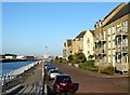
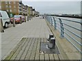
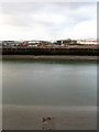
Britannia Avenue, Shoreham Beach
A view of the waterfront that was once Sussex Wharf and redeveloped in 2005.
Image: © Simon Carey
Taken: 19 May 2020
0.04 miles
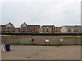
2
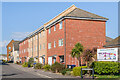
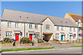
2 - 12 Providence Way
Terrace of houses on a cul-de-sac off Harbour Way built in 2012.
Image: © Ian Capper
Taken: 17 Mar 2022
0.04 miles
3
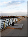
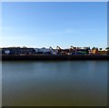
Sussex Wharf
Former timber wharf converted to housing a few years ago ending any industrial activity south of the river on the western arm. Railway Wharf is opposite whilst the chimney of Shoreham Power Station can be seen in the distance.
Image: © Simon Carey
Taken: 29 Mar 2009
0.05 miles
4
Sea Spray Avenue, Shoreham Beach
This row of modern terraced houses occupies the delightfully named Sea Spray Avenue. At one time Shoreham Beach was noted for its holiday bungalows, some of them based on old wooden railway carriages, one of which was called 'Sea Spray'. That may have been the inspiration for the name here.
Image: © Stephen McKay
Taken: 16 Aug 2023
0.05 miles
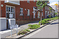
5
Harbour House
Terrace of houses on Harbour Way built in 1999.
Image: © Ian Capper
Taken: 17 Mar 2022
0.06 miles
6
Shoreham Harbour, Sussex Wharf
Disused wharf, though mooring posts and rungs to the water have been retained. The wharf now comprises apartment blocks.
Image: © Mike Faherty
Taken: 7 Apr 2018
0.07 miles
7
73 - 79 Harbour Way
Terrace of houses on Harbour Way built in 2006.
Image: © Ian Capper
Taken: 17 Mar 2022
0.08 miles
8
Egypt Wharf
Named after a former 19th century settlement located to the west of the old lighthouse (To the east was another called Alexandria). Currently occupied by a scrap metal merchant though for how long as most of the old wharves are being redeveloped for housing.
Image: © Simon Carey
Taken: 19 May 2020
0.09 miles
9
Egypt Wharf
Viewed from Sussex Wharf and currently unused. Named after a small settlement called Egypt on the opposite bank rather than any links with the country.
Image: © Simon Carey
Taken: 29 Mar 2009
0.10 miles
10
Railway Wharf
See Image for a full history of the wharf. Across the river is the recent development on Sussex Wharf formerly filled with timber warehouses and now a new riverside residential location. Part of the problem Shoreham Harbour has is the constant battle between the residents on the southern side of the Adur and the industrial concerns on the northern side of what is a small, busy working port.
Image: © Simon Carey
Taken: 1 Feb 2009
0.10 miles