IMAGES TAKEN NEAR TO
St. Nicolas Lane, SHOREHAM-BY-SEA, BN43 5NY
Introduction
This page details the photographs taken nearby to St. Nicolas Lane, BN43 5NY by members of the Geograph project.
The Geograph project started in 2005 with the aim of publishing, organising and preserving representative images for every square kilometre of Great Britain, Ireland and the Isle of Man.

There are currently over 7.5m images from over14,400 individuals and you can help contribute to the project by visiting https://www.geograph.org.uk
Image Map
Images are licensed for reuse under creativecommons.org/licenses/by-sa/2.0
Notes
- Clicking on the map will re-center to the selected point.
- The higher the marker number, the further away the image location is from the centre of the postcode.
Image Listing (232 Images Found)
Images are licensed for reuse under creativecommons.org/licenses/by-sa/2.0
Image
Details
Distance
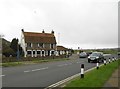
1
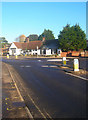
Red Lion, Steyning Road, Old Shoreham
A pub on the A283 next to the junction with Upper Shoreham Road. Until 1968 this was the A27/A283 junction with the road continuing to travel westwards over the old Toll Bridge opposite the church. The building dates from at least the 18th century and may be earlier and was once on the small strand area of the village until the coming of the road over the river in 1783 and the building of the new turnpike which became the A283 in 1807.
Image: © Simon Carey
Taken: 7 Dec 2008
0.02 miles
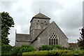
4
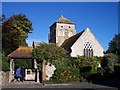
Old Shoreham Church
Dedicated to Saint Nicolas. Old Shoreham was the original town before the Normans laid out the new town closer to the sea on a grid pattern of streets.
Image: © Bob Embleton
Taken: 2 Oct 2005
0.03 miles
5

Old Shoreham from the West of the Adur
Showing the Old Shoreham Church and the Toll Bridge from the western bank of the Adur. Taken in 1981.
Image: © Alan Newbury
Taken: Unknown
0.03 miles
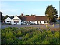
6
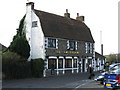
Shoreham-by-Sea: The Amsterdam
The village of Old Shoreham was here, around the eastern end of the main bridge over the River Adur, and completely separate from New Shoreham to the south. The village has now been swallowed up by the suburban sprawl of Shoreham-by-Sea, but there are a few buildings left from the old village. The Amsterdam is one of them, but despite appearances to the contrary, it is not an old public house, but a house that has been converted into a restaurant. It is however a Grade II Listed Building and the English Heritage website describes it thus:-
"House, now restaurant. Early C18. Flint with painted cobbled return fronts and painted brick quoins and dressings. Plain tiled mansard roof with end stack and ridge stack to right. Two storeys and garrets; irregular fenestration of 3 windows on first floor and 5 on ground-floor, the 4 to left in long line. Diamond lattice casements, on ground-floor with segment heads. Entrance with glazed door between first and second windows from right."
Image: © Nigel Cox
Taken: 5 Feb 2016
0.03 miles
7
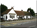
Red Lion Inn, Steyning Road, Old Shoreham
Parts of the building are said to date from the 16th century though much was rebuilt in the 18th.
Image: © Simon Carey
Taken: 25 May 2020
0.03 miles
9
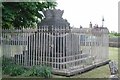
St Nicolas, Old Shoreham, Sussex - Churchyard
Image: © John Salmon
Taken: 10 May 2003
0.04 miles
10
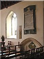
St Nicholas, Old Shoreham, Sussex - Interior
Image: © John Salmon
Taken: 10 May 2003
0.04 miles