IMAGES TAKEN NEAR TO
Mariners Close, SHOREHAM-BY-SEA, BN43 5LU
Introduction
This page details the photographs taken nearby to Mariners Close, BN43 5LU by members of the Geograph project.
The Geograph project started in 2005 with the aim of publishing, organising and preserving representative images for every square kilometre of Great Britain, Ireland and the Isle of Man.

There are currently over 7.5m images from over14,400 individuals and you can help contribute to the project by visiting https://www.geograph.org.uk
Image Map
Images are licensed for reuse under creativecommons.org/licenses/by-sa/2.0
Notes
- Clicking on the map will re-center to the selected point.
- The higher the marker number, the further away the image location is from the centre of the postcode.
Image Listing (92 Images Found)
Images are licensed for reuse under creativecommons.org/licenses/by-sa/2.0
Image
Details
Distance
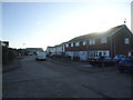
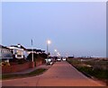
1
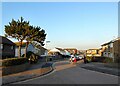
Kings Crescent, Shoreham By Sea
Residential road linking West Beach to Kings Drive. It was initially laid out in the 1920s but realigned and rebuilt during the 1960s.
Image: © Simon Carey
Taken: 27 Feb 2021
0.02 miles
3

New Salts Farm
Nr the centre of the square, north of the A259 roundabout.
Image: © Chris Shaw
Taken: 19 Jun 2005
0.05 miles
4
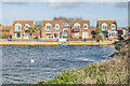
9 - 13 Seahaven Gardens
Row of houses overlooking the east end of Widewater.
Image: © Ian Capper
Taken: 15 Jan 2023
0.05 miles
5
Fishermans Walk
Cul de sac off Kings Crescent. In the distance on the far left hand edge of the photo is Lancing College Chapel.
Image: © Ian Capper
Taken: 15 Jan 2023
0.06 miles
7
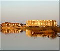
Widewater Court, Kings Crescent, Shoreham By Sea
Large block of flats located at the eastern end of the lagoon that was built in the 1960s.
Image: © Simon Carey
Taken: 27 Feb 2021
0.07 miles
8
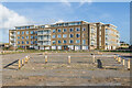
Widewater Court
Apartment block overlooking the east end of Widewater.
Image: © Ian Capper
Taken: 15 Jan 2023
0.07 miles
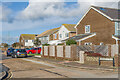
9
West Beach Road
Houses on West Beach Road. On the left is part of Widewater Court.
Image: © Ian Capper
Taken: 15 Jan 2023
0.08 miles
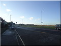
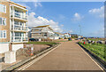
10
West Beach, Shoreham By Sea
The name of the road that runs westwards from Kings Walk to the Widewater Car Park. Some maps have this as West Beach Road but the road signs on the ground specifically state it as West Beach.
Image: © Simon Carey
Taken: 27 Feb 2021
0.08 miles