IMAGES TAKEN NEAR TO
Emerald Quay, SHOREHAM-BY-SEA, BN43 5JJ
Introduction
This page details the photographs taken nearby to Emerald Quay, BN43 5JJ by members of the Geograph project.
The Geograph project started in 2005 with the aim of publishing, organising and preserving representative images for every square kilometre of Great Britain, Ireland and the Isle of Man.

There are currently over 7.5m images from over14,400 individuals and you can help contribute to the project by visiting https://www.geograph.org.uk
Image Map
Images are licensed for reuse under creativecommons.org/licenses/by-sa/2.0
Notes
- Clicking on the map will re-center to the selected point.
- The higher the marker number, the further away the image location is from the centre of the postcode.
Image Listing (105 Images Found)
Images are licensed for reuse under creativecommons.org/licenses/by-sa/2.0
Image
Details
Distance
1
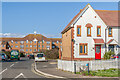
Anchor Close
Cul-de-sac off Harbour Way, with Waters Edge, a 2001 apartment block, in the background.
Image: © Ian Capper
Taken: 17 Mar 2022
0.03 miles
2
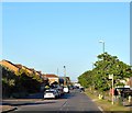
Harbour Way, Shoreham Beach
Residential road linking Riverside Road to Old Fort Road.
Image: © Simon Carey
Taken: 19 May 2020
0.03 miles
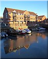
3

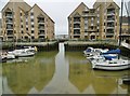
Fishing boats at Emerald Quay
The marina is tidal so can only be entered and left at high tide. Although the water can at times look a bit green, it does contain fish and most evenings a family of swans glide around. Berths can only be owned by residents, some of whom do not have boats so rent out the berths for extra income. http://www.fredshed.co.uk/emeraldquay.htm
Image: © Paul Gillett
Taken: 16 Apr 2011
0.05 miles
4
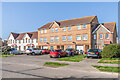
11 - 27 Harbour Way
One block in a group of terraces, nos 1 - 65 Harbour Way, built in 1999.
Image: © Ian Capper
Taken: 17 Mar 2022
0.05 miles
5
Emerald Quay Marina
The small locked basin was built as part of the Emerald Quay development.
Image: © Simon Carey
Taken: 19 May 2020
0.06 miles
6
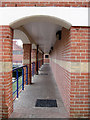
Walkway, Emerald Quay
Cover path that follows the western side of the small marina within Emerald Quay. The waterside development was begun in 1986 and completed in the 1990s on the site of a former boatyard.
Image: © Simon Carey
Taken: 29 Mar 2009
0.06 miles
7
Shoreham Harbour, Emerald Quay
An inlet off the harbour; now residential, with private moorings.
Image: © Mike Faherty
Taken: 7 Apr 2018
0.06 miles
9
Harbour Way
Part of a group of terraces, nos 1 - 65 Harbour Way, built in 1999.
Image: © Ian Capper
Taken: 17 Mar 2022
0.07 miles
10

Osprey Walk
Flats by the Riverside, Shoreham Beach
Image: © Paul Gillett
Taken: 16 Apr 2011
0.07 miles