IMAGES TAKEN NEAR TO
Feversham Close, SHOREHAM-BY-SEA, BN43 5HD
Introduction
This page details the photographs taken nearby to Feversham Close, BN43 5HD by members of the Geograph project.
The Geograph project started in 2005 with the aim of publishing, organising and preserving representative images for every square kilometre of Great Britain, Ireland and the Isle of Man.

There are currently over 7.5m images from over14,400 individuals and you can help contribute to the project by visiting https://www.geograph.org.uk
Image Map
Images are licensed for reuse under creativecommons.org/licenses/by-sa/2.0
Notes
- Clicking on the map will re-center to the selected point.
- The higher the marker number, the further away the image location is from the centre of the postcode.
Image Listing (80 Images Found)
Images are licensed for reuse under creativecommons.org/licenses/by-sa/2.0
Image
Details
Distance
1
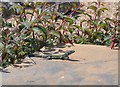
Wall Lizard, Shoreham Beach
Wall Lizards seem to have been present in this area for a number of years, seen on warm days sunning themselves on walls. They can be seen at nearby Shoreham Fort and along Beach Road.
Image: © Peter Whitcomb
Taken: 5 Jun 2008
0.08 miles
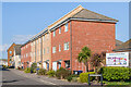
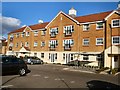
2

Harbour House
Terrace of houses on Harbour Way built in 1999.
Image: © Ian Capper
Taken: 17 Mar 2022
0.08 miles
3
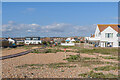
Shoreham Beach
The rear of houses in Old Fort Road overlooking the beach at Shoreham Beach.
Image: © Ian Capper
Taken: 17 Mar 2022
0.08 miles
4
Shoreham Beach
The rear of houses in Old Fort Road overlooking the beach at Shoreham Beach.
Image: © Ian Capper
Taken: 17 Mar 2022
0.08 miles
5
2 - 12 Providence Way
Terrace of houses on a cul-de-sac off Harbour Way built in 2012.
Image: © Ian Capper
Taken: 17 Mar 2022
0.09 miles
6
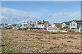
Shoreham Beach
The rear of houses in Old Fort Road overlooking the beach at Shoreham Beach.
Image: © Ian Capper
Taken: 15 Jan 2023
0.10 miles
7
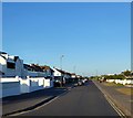
Old Fort Road, Shoreham Beach
Viewed from the junction with Winterton Way.
Image: © Simon Carey
Taken: 19 May 2020
0.10 miles
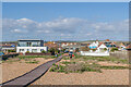
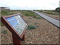
8
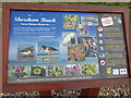
Information board for Shoreham Beach
As can be seen here Shoreham Beach became a Local Nature Reserve in 2006 because of its habitat of vegetated shingle. A Friends of Shoreham Beach was set up to help conserve and protect this environment and raise public awareness. Their information board can be seen where Winterton Way continues on to the beach.
Image: © Marathon
Taken: 30 Sep 2017
0.10 miles
9
South Wharf House
Located In Hancock Way, Shoreham Beach
Image: © Paul Gillett
Taken: 19 Feb 2012
0.10 miles
10
The approach to Shoreham Beach
Shoreham Beach became a Local Nature Reserve in 2006 because of its habitat of vegetated shingle. A Friends of Shoreham Beach was set up to help conserve and protect this environment and raise public awareness. Their information board can be seen on the left. A close-up of the board is at http://www.geograph.org.uk/photo/5556463 This is the approach from Winterton Way.
Image: © Marathon
Taken: 30 Sep 2017
0.10 miles