IMAGES TAKEN NEAR TO
Steyning Road, SHOREHAM-BY-SEA, BN43 5FH
Introduction
This page details the photographs taken nearby to Steyning Road, BN43 5FH by members of the Geograph project.
The Geograph project started in 2005 with the aim of publishing, organising and preserving representative images for every square kilometre of Great Britain, Ireland and the Isle of Man.

There are currently over 7.5m images from over14,400 individuals and you can help contribute to the project by visiting https://www.geograph.org.uk
Image Map (Loading...)


Getting Data...Please wait
Leaflet Map data © OpenStreetMap
Images are licensed for reuse under creativecommons.org/licenses/by-sa/2.0
Notes
- Clicking on the map will re-center to the selected point.
- The higher the marker number, the further away the image location is from the centre of the postcode.
Image Listing (34 Images Found)
Images are licensed for reuse under creativecommons.org/licenses/by-sa/2.0
Image
Details
Distance
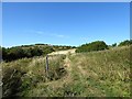
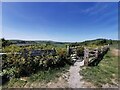
1
Path through the access land on Mill Hill
Covered reservoir forms the horizon.
Image: © Dave Spicer
Taken: 30 Jan 2011
0.04 miles
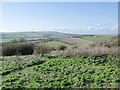
2
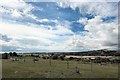
The Coastal Plain
Viewed from Mill Hill, with Shoreham Airport on the left horizon and Lancing College in the trees to the right.
Image: © Peter Jeffery
Taken: 24 Aug 2020
0.06 miles
3
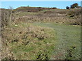
Mill Hill Nature Reserve
Small open access nature reserve located on the western side of Mill Hill as it drops down into the Adur Valley.
Image: © Simon Carey
Taken: 5 Aug 2018
0.07 miles
4
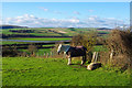
Pony and sheep on Mill Hill
Rather cold with a breeze, but at least there's sun, a view and a coat for the pony.
Image: © Robin Webster
Taken: 15 Jan 2016
0.07 miles
6
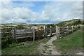
Mill Hill Nature Reserve
The Southern Entrance
Image: © Peter Jeffery
Taken: 24 Aug 2020
0.07 miles
7
Footpath and seat on Mill Hill, Shoreham, West Sussex
The buildings in the background are Old Erringham Farm. In the Middle Ages this was the village of Erringham and the chapel remains are noted on O/S maps. The use of chapel rather than church suggests the village was small however.
Image: © nick macneill
Taken: 5 Apr 2010
0.09 miles
8
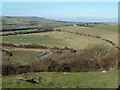
River Adur flood plain at the base of Mill Hill
Image: © Dave Spicer
Taken: 30 Jan 2011
0.12 miles
9

Lower Slopes of Mill Hill in winter
18 December 2009
Image: © Andy Horton
Taken: 18 Dec 2009
0.18 miles
10
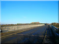
Mill Hill Bridge
Carrying the former medieval main route out of Shoreham over the modern day by-pass. The house on the far side is called Dolphins.
Image: © Simon Carey
Taken: 7 Dec 2008
0.19 miles