IMAGES TAKEN NEAR TO
Old Shoreham Road, SHOREHAM-BY-SEA, BN43 5FG
Introduction
This page details the photographs taken nearby to Old Shoreham Road, BN43 5FG by members of the Geograph project.
The Geograph project started in 2005 with the aim of publishing, organising and preserving representative images for every square kilometre of Great Britain, Ireland and the Isle of Man.

There are currently over 7.5m images from over14,400 individuals and you can help contribute to the project by visiting https://www.geograph.org.uk
Image Map
Images are licensed for reuse under creativecommons.org/licenses/by-sa/2.0
Notes
- Clicking on the map will re-center to the selected point.
- The higher the marker number, the further away the image location is from the centre of the postcode.
Image Listing (122 Images Found)
Images are licensed for reuse under creativecommons.org/licenses/by-sa/2.0
Image
Details
Distance

2
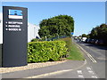
Sign at Shoreham Technical Centre by Old Shoreham Road
Image: © Shazz
Taken: 7 Sep 2016
0.02 miles
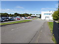
3

Front of the Ricardo reception building
Among many other things, Ricardo designs and manufactures engines for McLaren road cars
Image: © David Gearing
Taken: 6 Sep 2013
0.03 miles
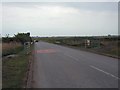
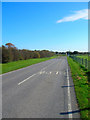
6
Old Shoreham Road
A road has existed here since medieval times when a padway led from the nearby Pad Inn over the marshes to a ferry crossing to Old Shoreham on the far side. This was replaced in 1782 by the current wooden bridge which remained the main east-west route until it was closed in 1970 after the completion of the nearby Shoreham by-pass. Hard to believe double decker buses and HGVs thundered down this narrow route and over the rickety bridge. Subsequently, this part of the former A27 has become an access road for Shoreham Airport and Ricardos Engineering as well as providing parking places for those using the footpaths on either side of the river.
Image: © Simon Carey
Taken: 7 Dec 2008
0.07 miles
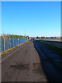
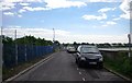
7
Almond Avenue
Airport access road that is closed to the public between 11.30pm and 6am.
Image: © Simon Carey
Taken: 18 Oct 2008
0.08 miles
8
Old Shoreham Road
Former route of the A27.
Image: © N Chadwick
Taken: 8 May 2011
0.08 miles
9
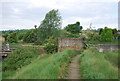
Pillbox by the River Adur
Image: © N Chadwick
Taken: 8 May 2011
0.08 miles
10

Pillbox near Shoreham Airport
Different view of Image taken from Cecil Pashley Way. No idea what the red flower is if somebody could enlighten me.
Image: © Simon Carey
Taken: 18 Oct 2008
0.08 miles