IMAGES TAKEN NEAR TO
Victoria Road, BRIGHTON, BN42 4DH
Introduction
This page details the photographs taken nearby to Victoria Road, BN42 4DH by members of the Geograph project.
The Geograph project started in 2005 with the aim of publishing, organising and preserving representative images for every square kilometre of Great Britain, Ireland and the Isle of Man.

There are currently over 7.5m images from over14,400 individuals and you can help contribute to the project by visiting https://www.geograph.org.uk
Image Map
Images are licensed for reuse under creativecommons.org/licenses/by-sa/2.0
Notes
- Clicking on the map will re-center to the selected point.
- The higher the marker number, the further away the image location is from the centre of the postcode.
Image Listing (166 Images Found)
Images are licensed for reuse under creativecommons.org/licenses/by-sa/2.0
Image
Details
Distance
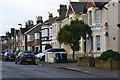
2
Lorry Park, The Grange Industrial Estate
The estate is out of shot to the right, the road in the foreground is Albion Street, the A259, whilst the embankment carrying the West Coastway line is beyond.
Image: © Simon Carey
Taken: 1 Feb 2009
0.07 miles
3
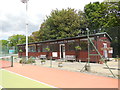
Sussex County Lawn Tennis club clubhouse
Based in Kingston Lane, Southwick http://www.scltc.co.uk/
Image: © Paul Gillett
Taken: 9 Jun 2015
0.08 miles
4
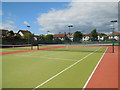
Tennis Courts, Southwick
At the Sussex County Lawn Tennis Club in Kingston Lane
Image: © Paul Gillett
Taken: 9 Jun 2015
0.09 miles
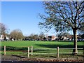
6

The Green
Looking across the cricket square on The Green. The road leading away in the background is Albert Road.
Image: © Ian Capper
Taken: 21 Jan 2022
0.10 miles
7

War Memorial
War memorial dating from 1922 to commemorate those from Southwick and Fishersgate who died in the First World War. Grade II listed - see https://historicengland.org.uk/listing/the-list/list-entry/1389099?section=official-listing.
Image: © Ian Capper
Taken: 21 Jan 2022
0.11 miles
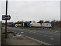
8
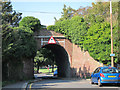
Railway bridge over Grange Road
Railway between Shoreham-by-Sea and Southwick Road stations.
Image: © Oast House Archive
Taken: 1 Sep 2011
0.11 miles
9
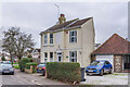
37 The Green
House on The Green, with a name plaque "Cherry Cottage".
Image: © Ian Capper
Taken: 21 Jan 2022
0.13 miles
10

The Green
Looking across the cricket square on The Green.
Image: © Ian Capper
Taken: 21 Jan 2022
0.13 miles