IMAGES TAKEN NEAR TO
Riverside, BRIGHTON, BN42 4AW
Introduction
This page details the photographs taken nearby to Riverside, BN42 4AW by members of the Geograph project.
The Geograph project started in 2005 with the aim of publishing, organising and preserving representative images for every square kilometre of Great Britain, Ireland and the Isle of Man.

There are currently over 7.5m images from over14,400 individuals and you can help contribute to the project by visiting https://www.geograph.org.uk
Image Map
Images are licensed for reuse under creativecommons.org/licenses/by-sa/2.0
Notes
- Clicking on the map will re-center to the selected point.
- The higher the marker number, the further away the image location is from the centre of the postcode.
Image Listing (232 Images Found)
Images are licensed for reuse under creativecommons.org/licenses/by-sa/2.0
Image
Details
Distance
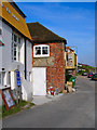
1
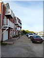
Cat Mews, Riverside, Southwick
Built in 2001 on the site of a former Shipbrokers. Riverside is the remnant of an old coastal turnpike route.
Image: © Simon Carey
Taken: 17 May 2020
0.01 miles
2
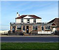
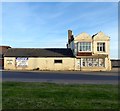
The Schooner Inn, Albion Street, Southwick
The inn extends down the cliff to Riverside and dates from at least the 19th century.
Image: © Simon Carey
Taken: 17 May 2020
0.01 miles
3
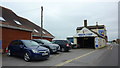
Arrow Tyres on Albion Street, Southwick
Image: © Richard Cooke
Taken: 5 Jun 2018
0.01 miles
4
Southwick, Schooner Inn
Public house on Albion Street. Central rectangular counter with eating and drinking areas front, right and back; excellent views across the harbour. Cask ales on offer at my visit: Downlands Thirteen, Franklin's F.
Image: © Mike Faherty
Taken: 7 Apr 2018
0.01 miles
5
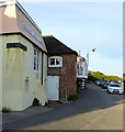
144, Albion Street, Southwick
Home to Arrow Tire Services with the section on the left once a 19th century smithy.
Image: © Simon Carey
Taken: 17 May 2020
0.01 miles
6
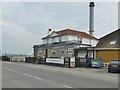
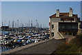
Sussex Yacht Club, Riverside, Southwick
The clubhouse was built in 1816 as a malthouse but has been the headquarters of the club since 1926.
Image: © Simon Carey
Taken: 17 May 2020
0.02 miles
7
On the Embankment
Former low lying cliffs now form the northern boundary of Shoreham Harbour which is to the left. To the right is Albion Street, the A259, with Albion Flats over the far side of the road. In the distance is the Schooner pub. A ruined bench is in the foreground with a dead fox to the side most likely run over on the main road.
Image: © Simon Carey
Taken: 25 Dec 2009
0.02 miles
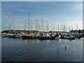
8
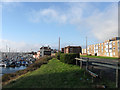
Overlooking the Marina, Southwick, Sussex
The small marina is located at the end of the canal, just before the locks into Shoreham Harbour.
Image: © Peter Trimming
Taken: 17 Apr 2010
0.02 miles
9
Riverside
Former 19th century warehouses near what was once the mouth of the Adur.
Image: © Simon Carey
Taken: 4 Apr 2008
0.03 miles
10
Sussex Yacht Club
The club has maintained moorings here since 1926.
Image: © Simon Carey
Taken: 17 May 2020
0.03 miles