IMAGES TAKEN NEAR TO
Graham Crescent, BRIGHTON, BN41 2YB
Introduction
This page details the photographs taken nearby to Graham Crescent, BN41 2YB by members of the Geograph project.
The Geograph project started in 2005 with the aim of publishing, organising and preserving representative images for every square kilometre of Great Britain, Ireland and the Isle of Man.

There are currently over 7.5m images from over14,400 individuals and you can help contribute to the project by visiting https://www.geograph.org.uk
Image Map
Images are licensed for reuse under creativecommons.org/licenses/by-sa/2.0
Notes
- Clicking on the map will re-center to the selected point.
- The higher the marker number, the further away the image location is from the centre of the postcode.
Image Listing (20 Images Found)
Images are licensed for reuse under creativecommons.org/licenses/by-sa/2.0
Image
Details
Distance
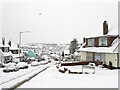
2
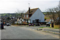
Thornhill Rise and Overdown Rise
Overdown Rise is at the right. Rise is appropriate for this residential area, at least in one direction. Southwick Hill is in the distance.
Image: © Robin Webster
Taken: 3 Apr 2010
0.11 miles
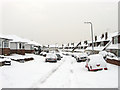
3
Thornhill Rise
The road turns west at the junction with Ridge Close and heads down the hill. Much of the area was developed during the 1960s.
Image: © Simon Carey
Taken: 2 Dec 2010
0.12 miles
4
New England Rise
Heading west down the hill from Thornhill Rise where it joins Graham Crescent. The estate was developed in the 1960s to rehouse those moved from Portslade by Sea. Southwick Hill can be seen in the distance.
Image: © Simon Carey
Taken: 2 Dec 2010
0.12 miles
5
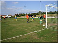
Mile Oak Park - Mile Oak Football Club (Sussex)
Oak are in orange, playing Lancing in yellow. I'm not sure what happened to the keeper, but he does not look comfortable. The only stand can be seen right of centre; a wooden structure facing the prevailing wind.
Image: © nick macneill
Taken: 6 Oct 2007
0.14 miles
6
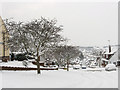
Thornhill Rise
Running along the western slope of Foredown Hill. the eastern part of Mile Oak was developed during the 1960s to place families moved from another redevelopment at Portslade by Sea.
Image: © Simon Carey
Taken: 2 Dec 2010
0.15 miles
7
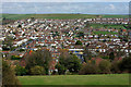
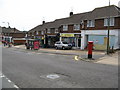
Mile Oak from Southwick Hill
The near road roughly in line with the view is Oakdeane Crescent, with a parade of shops opposite its junction with Mile Oak Road.
Image: © Robin Webster
Taken: 3 Apr 2010
0.17 miles
8
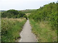
Start of Public Bridleway behind Ridge Close
Image: © Josie Campbell
Taken: 2 Aug 2011
0.18 miles
9
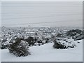
Mile Oak from Southwick Hill
View east over Mile Oak to Foredown Hill on the skyline. Foredown Tower is to the right of centre on this skyline with the white pinnacle roof.
Built as a water tower serving the adjacent former Foredown Hospital, it is now a Camera Obscura http://www.daysoutguide.co.uk/foredown-tower-countryside-centre
Image: © Dave Spicer
Taken: 2 Dec 2010
0.20 miles