IMAGES TAKEN NEAR TO
Locks Hill, BRIGHTON, BN41 2LD
Introduction
This page details the photographs taken nearby to Locks Hill, BN41 2LD by members of the Geograph project.
The Geograph project started in 2005 with the aim of publishing, organising and preserving representative images for every square kilometre of Great Britain, Ireland and the Isle of Man.

There are currently over 7.5m images from over14,400 individuals and you can help contribute to the project by visiting https://www.geograph.org.uk
Image Map
Images are licensed for reuse under creativecommons.org/licenses/by-sa/2.0
Notes
- Clicking on the map will re-center to the selected point.
- The higher the marker number, the further away the image location is from the centre of the postcode.
Image Listing (54 Images Found)
Images are licensed for reuse under creativecommons.org/licenses/by-sa/2.0
Image
Details
Distance
1
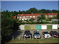
Kemps Court garages looking on to Locks Crescent, Portslade
Suburbia Portslade style. The photo is taken from Kemps court, a set of flats built in the early seventies
Image: © nick macneill
Taken: 23 Jun 2009
0.04 miles
2
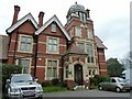
Loxdale off Locks Hill Portslade
Built in 1899 by the Mews brothers, who owned the nearby brewery, the house remained in the family until 1928.
Since then the house has become a Boys Home, an approved school for girls, a Senior citizen Holiday Home and now the Swedish Folk High School.
Image: © Dave Spicer
Taken: 31 Mar 2012
0.05 miles
3
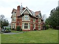
The rear of Loxdale house
Information concerning Loxdale see Image
Image: © Dave Spicer
Taken: 31 Mar 2012
0.05 miles
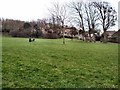
5
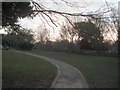
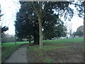
Path through Easthill Park
On the edge of historic old Portslade Village is Easthill Park, which once formed part of nearby Easthill House, built in 1851
http://www.brighton-hove.gov.uk/index.cfm?request=c1001409
Image: © Paul Gillett
Taken: 6 Dec 2009
0.09 miles
6
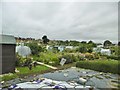
Portslade Village, allotments
On Windlesham Close. http://www.portsladehorticulturalsociety.com/
Image: © Mike Faherty
Taken: 11 Aug 2018
0.10 miles
7
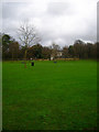
Recreation Ground
Occupying the area bounded by South Street to the north and Locks Hill to the east. The building screened by the trees is Manor Lodge.
Image: © Simon Carey
Taken: 9 Dec 2007
0.10 miles
8
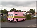
Camper van in pink with gold ring, Portslade
Nice... The van is in Windlesham Road, originally called Camp Close, as it was used as a military camp during the First World War.
Image: © nick macneill
Taken: 10 Jun 2011
0.11 miles
9
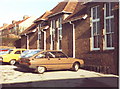
Portslade Infants School, Locks Crescent
The building was a teacher training unit at the time of the photo, but was an infants school before that and the cars are parked in the playground where I once played 'Cowboys and Indians' and had my first kiss!
Image: © nick macneill
Taken: Unknown
0.11 miles
10
Easthill Park
On the edge of historic old Portslade Village is Easthill Park, which once formed part of nearby Easthill House, built in 1851
http://www.brighton-hove.gov.uk/index.cfm?request=c1001409
Image: © Paul Gillett
Taken: 6 Dec 2009
0.12 miles