IMAGES TAKEN NEAR TO
Fox Way, BRIGHTON, BN41 2HW
Introduction
This page details the photographs taken nearby to Fox Way, BN41 2HW by members of the Geograph project.
The Geograph project started in 2005 with the aim of publishing, organising and preserving representative images for every square kilometre of Great Britain, Ireland and the Isle of Man.

There are currently over 7.5m images from over14,400 individuals and you can help contribute to the project by visiting https://www.geograph.org.uk
Image Map
Images are licensed for reuse under creativecommons.org/licenses/by-sa/2.0
Notes
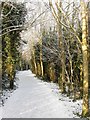
- Clicking on the map will re-center to the selected point.
- The higher the marker number, the further away the image location is from the centre of the postcode.
Image Listing (22 Images Found)
Images are licensed for reuse under creativecommons.org/licenses/by-sa/2.0
Image
Details
Distance
1
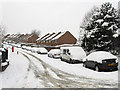
Hangleton Lane
Once a narrow farm track that linked Hangleton Farm to Portslade village that has been swallowed up by development in the 20th century. Viewed from the junction with Dean Gardens.
Image: © Simon Carey
Taken: 2 Dec 2010
0.05 miles
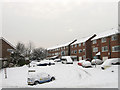
2
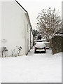
Vallensdean Cottages
Small terrace of cottages lying at right angles to Hangleton Lane that state on the plaque to the left that they were built in 1825 though they don't appear on the 1879 OS map. For a many decades these were the only buildings on Hangleton Lane until eventually swallowed up by suburbia.
Image: © Simon Carey
Taken: 2 Dec 2010
0.06 miles
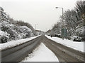
3
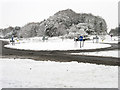
Roundabout, Hangleton Link Road
Other than the entrance to Sainsbury's further south the only access points to the A293, from the west is Fox Way that links the suburb of Mile Oak and to the east Hangleton Lane which leads to the suburb of Hangleton. Not surprisingly after 8-10 inches of snow fell overnight there is very little traffic on this normally busy route.
Image: © Simon Carey
Taken: 2 Dec 2010
0.06 miles
4
Entrance to the Benfield Valley Golf Course
This 9 hole course uses some of the old West Hove Golf Course holes.
With the building of the Brighton Bypass and the subsequent link road, the West Hove Golf Club were relocated to north of the bypass. The former clubhouse was south of the present Sainsbury's car park.
Image: © Dave Spicer
Taken: 18 Dec 2012
0.07 miles
5
New Barn Close
A cul-de-sac off Fox Way developed along with that road in the 1990s.
Image: © Simon Carey
Taken: 2 Dec 2010
0.09 miles
6
Benfield Valley Local Nature Reserve
A narrow strip of land separating Portslade from the suburb of Hangleton. Formerly part of West Hove Golf Club which operated here from 1910 to 1991 before the by-pass split their course in two and took away some land to build the Hangleton Link Road caused them to relocate north of the A27. This section between Sainsbury's and Hangleton Lane is now an open public space with footpaths linking the nature reserve with the two suburbs mentioned above.
Image: © Simon Carey
Taken: 7 Jan 2010
0.14 miles
7
Hangleton Link Road
The A293 that was built in the early 1990s to link the old course of the A27, now the A270, to the new one being constructed as the Brighton By-Pass. For a brief period this road was the A27 prior to the section between the Hangleton and Holmbush Interchanges being completed. Normally a busy road the only traffic on this day is a man struggling through the snow with his shopping from Sainsbury's.
Image: © Simon Carey
Taken: 2 Dec 2010
0.15 miles
8
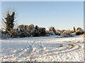
Car Park, Benfield Valley Golf Course
The 9 hole golf course is situated in the northern part of Benfield Valley using some of the fairways vacated by West Hove Golf Course when it relocated north of the A27. The chimney in view is one of the few structural remains of a row of late 19th century agricultural labourer's cottages that were built on the site of Benfield Manor Farm which was demolished in 1871.
Image: © Simon Carey
Taken: 7 Jan 2010
0.17 miles
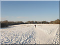
9
Footpath and Cycleway, Benfield Valley
Part of the Benfield Valley Nature Reserve the footpath and cycleway start on the A270 and follow the eastern side of the reserve to Hangleton Lane then beyond up to the A270 before turning east and heading down to Hangleton.
Image: © Simon Carey
Taken: 7 Jan 2010
0.17 miles
10
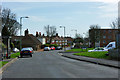
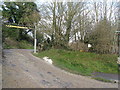
Foredown Road
Foredown Road joins Mill Lane just beyond the parked cars on the left.
Image: © Robin Webster
Taken: 3 Apr 2010
0.17 miles