IMAGES TAKEN NEAR TO
Foredown Road, BRIGHTON, BN41 2GB
Introduction
This page details the photographs taken nearby to Foredown Road, BN41 2GB by members of the Geograph project.
The Geograph project started in 2005 with the aim of publishing, organising and preserving representative images for every square kilometre of Great Britain, Ireland and the Isle of Man.

There are currently over 7.5m images from over14,400 individuals and you can help contribute to the project by visiting https://www.geograph.org.uk
Image Map
Images are licensed for reuse under creativecommons.org/licenses/by-sa/2.0
Notes
- Clicking on the map will re-center to the selected point.
- The higher the marker number, the further away the image location is from the centre of the postcode.
Image Listing (20 Images Found)
Images are licensed for reuse under creativecommons.org/licenses/by-sa/2.0
Image
Details
Distance
1
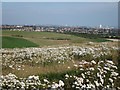
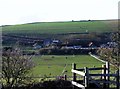
Farmland near Foredown Hill
View to Brighton and Hove.
Image: © Oast House Archive
Taken: 1 Sep 2011
0.03 miles
2
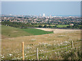
Farmland near Foredown Hill
View to Brighton and Hove.
Image: © Oast House Archive
Taken: 1 Sep 2011
0.03 miles
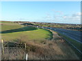
5
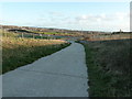
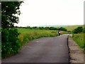
The Monarch's Way
Although appearing to approach Brighton and Hove the path turns acutely left.
Image: © Dave Spicer
Taken: 2 Jan 2012
0.10 miles
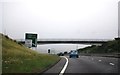
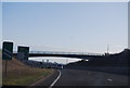
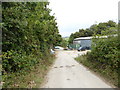
9
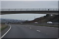
A27 Brighton Bypass
Eastbound passing Hangleton Valley on the right.
Image: © Dave Spicer
Taken: 2 Jan 2012
0.14 miles