IMAGES TAKEN NEAR TO
Foredown Road, BRIGHTON, BN41 2FU
Introduction
This page details the photographs taken nearby to Foredown Road, BN41 2FU by members of the Geograph project.
The Geograph project started in 2005 with the aim of publishing, organising and preserving representative images for every square kilometre of Great Britain, Ireland and the Isle of Man.

There are currently over 7.5m images from over14,400 individuals and you can help contribute to the project by visiting https://www.geograph.org.uk
Image Map
Images are licensed for reuse under creativecommons.org/licenses/by-sa/2.0
Notes
- Clicking on the map will re-center to the selected point.
- The higher the marker number, the further away the image location is from the centre of the postcode.
Image Listing (47 Images Found)
Images are licensed for reuse under creativecommons.org/licenses/by-sa/2.0
Image
Details
Distance
1
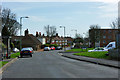
Foredown Road
Foredown Road joins Mill Lane just beyond the parked cars on the left.
Image: © Robin Webster
Taken: 3 Apr 2010
0.14 miles
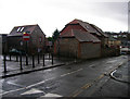
3
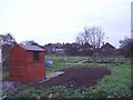
The allotments north of the Old Shoreham Road Portslade
Image: © DAVIDJARRETT
Taken: 3 Dec 2006
0.14 miles
4
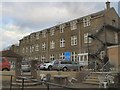
Emmaus Cafe
The Emmaus community is located in an old manor house in Portslade Old village, the community provides work and support for people coming out of homelessness http://www.emmausbrighton.co.uk/default.asp
Image: © Paul Gillett
Taken: 21 Jan 2012
0.15 miles
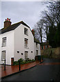
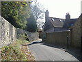
6
Old Riding Stables, Drove Road
At the junction with High Street are two old flint buildings that have been converted to residential use, the Old Stables to the right and the Old Barn to the left.
Image: © Simon Carey
Taken: 9 Dec 2007
0.17 miles
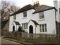
7
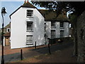
Kemps, High Street, Portslade Village
Situated on the bend towards the top of High Street is Kemps, a grade II listed building is the oldest habitable house in Portslade, built c1580 probably by the Blaker’s and extended c1650. It remained as the Blaker family home till at least 1854 when Cordelia’s will stated it be sold and divided up between the rest of the siblings. The property built as a detached farmhouse is now 2 dwellings.
Image: © Josie Campbell
Taken: 2 Aug 2011
0.18 miles
8
Kemps, High Street
At the eastern end of High Street and built around 1540 for the Blaker family whose descendants lived in the house until 1869.
Image: © Simon Carey
Taken: 9 Dec 2007
0.18 miles
9
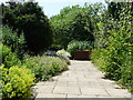
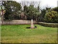
Walled Garden, Easthill Park
Opened to the public in 1947 the park covers 2.4 hectares. The walled garden contains well stocked herbaceous borders.
Image: © Janine Forbes
Taken: 15 Jul 2005
0.18 miles
10
High Street Portslade
The Drove Road end of the High Street looking south towards Kemps, with the flint wall of Emmaus on the left.
Image: © Pip Tindall
Taken: 19 Sep 2008
0.18 miles