IMAGES TAKEN NEAR TO
Easthill Drive, BRIGHTON, BN41 2FE
Introduction
This page details the photographs taken nearby to Easthill Drive, BN41 2FE by members of the Geograph project.
The Geograph project started in 2005 with the aim of publishing, organising and preserving representative images for every square kilometre of Great Britain, Ireland and the Isle of Man.

There are currently over 7.5m images from over14,400 individuals and you can help contribute to the project by visiting https://www.geograph.org.uk
Image Map
Images are licensed for reuse under creativecommons.org/licenses/by-sa/2.0
Notes
- Clicking on the map will re-center to the selected point.
- The higher the marker number, the further away the image location is from the centre of the postcode.
Image Listing (23 Images Found)
Images are licensed for reuse under creativecommons.org/licenses/by-sa/2.0
Image
Details
Distance
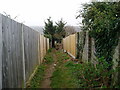
1
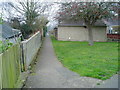
Public right of way
Footpath linking Mill Lane to Easthill Way.
Image: © Peter Holmes
Taken: 17 Mar 2012
0.08 miles
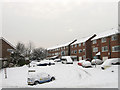
2
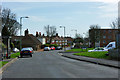
Foredown Road
Foredown Road joins Mill Lane just beyond the parked cars on the left.
Image: © Robin Webster
Taken: 3 Apr 2010
0.13 miles
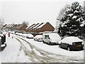
3
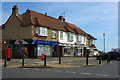
Post Office and shops, Portslade
It may not be Portslade - it is hard to tell where the zones of the urban sprawl start and finish. It is certainly on the corner of Burlington Gardens and Mill Lane.
Image: © Robin Webster
Taken: 3 Apr 2010
0.15 miles
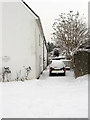
4
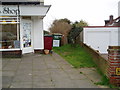
Start of public footpath at Mill Lane
Route from Portslade to Hangleton.
Image: © Peter Holmes
Taken: 17 Mar 2012
0.16 miles
5
New Barn Close
A cul-de-sac off Fox Way developed along with that road in the 1990s.
Image: © Simon Carey
Taken: 2 Dec 2010
0.17 miles
6
Hangleton Lane
Once a narrow farm track that linked Hangleton Farm to Portslade village that has been swallowed up by development in the 20th century. Viewed from the junction with Dean Gardens.
Image: © Simon Carey
Taken: 2 Dec 2010
0.18 miles
7
Vallensdean Cottages
Small terrace of cottages lying at right angles to Hangleton Lane that state on the plaque to the left that they were built in 1825 though they don't appear on the 1879 OS map. For a many decades these were the only buildings on Hangleton Lane until eventually swallowed up by suburbia.
Image: © Simon Carey
Taken: 2 Dec 2010
0.18 miles
8
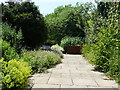
Walled Garden, Easthill Park
Opened to the public in 1947 the park covers 2.4 hectares. The walled garden contains well stocked herbaceous borders.
Image: © Janine Forbes
Taken: 15 Jul 2005
0.18 miles
9
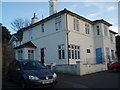
Easthill Park House
In the middle of Easthill Park, near Portslade Old Village
Image: © Paul Gillett
Taken: 6 Dec 2009
0.18 miles
10
Public footpath between Mill Lane and Benfield Way
Route from Portslade to Hangleton.
Image: © Peter Holmes
Taken: 17 Mar 2012
0.20 miles