IMAGES TAKEN NEAR TO
Benfield Crescent, BRIGHTON, BN41 2DB
Introduction
This page details the photographs taken nearby to Benfield Crescent, BN41 2DB by members of the Geograph project.
The Geograph project started in 2005 with the aim of publishing, organising and preserving representative images for every square kilometre of Great Britain, Ireland and the Isle of Man.

There are currently over 7.5m images from over14,400 individuals and you can help contribute to the project by visiting https://www.geograph.org.uk
Image Map
Images are licensed for reuse under creativecommons.org/licenses/by-sa/2.0
Notes
- Clicking on the map will re-center to the selected point.
- The higher the marker number, the further away the image location is from the centre of the postcode.
Image Listing (28 Images Found)
Images are licensed for reuse under creativecommons.org/licenses/by-sa/2.0
Image
Details
Distance
1
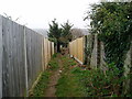
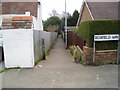
Public footpath between Mill Lane and Benfield Way
Route from Portslade to Hangleton.
Image: © Peter Holmes
Taken: 17 Mar 2012
0.18 miles
2
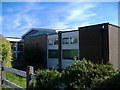
Portslade Library
A branch library opened in 1964
Image: © Pip Tindall
Taken: 19 Sep 2008
0.18 miles
3
Start of public footpath at Mill Lane
Route from Portslade to Hangleton.
Image: © Peter Holmes
Taken: 17 Mar 2012
0.18 miles
4
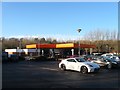
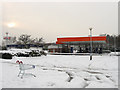
Sainsbury's Petrol Station, Hove
Located off the Hangleton Link Road, the A293, and opened in the early 1990s.
Image: © Simon Carey
Taken: 22 Dec 2016
0.19 miles
5
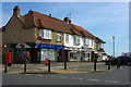
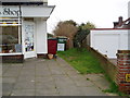
Post Office and shops, Portslade
It may not be Portslade - it is hard to tell where the zones of the urban sprawl start and finish. It is certainly on the corner of Burlington Gardens and Mill Lane.
Image: © Robin Webster
Taken: 3 Apr 2010
0.19 miles
6
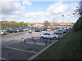
Sainsbury's Petrol Station
At the southern end of the car park for the superstore.
Image: © Simon Carey
Taken: 2 Dec 2010
0.20 miles
7
Public Footpath from Benfield Way
Route from Portslade to Hangleton.
Image: © Peter Holmes
Taken: 17 Mar 2012
0.20 miles
9
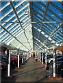
Covered Walkway, Sainsbury's, Hove
Providing some protection from the elements if you happen to be able to park next to it.
Image: © Simon Carey
Taken: 22 Dec 2016
0.21 miles
10
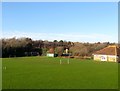
Benfield Valley Pavilion, Hove
The sports pavilion for the football and cricket pitches. Located to north of Old Shoreham Road, the A270 it was originally the southern most field in the parish of Hangleton called Upper and Lower Dean according to its 1841 tithe map. In 1910 Benfield valley was converted into the West Hove Golf Course who remained until 1991 when construction of the Brighton By-Pass including the Hangleton Link Road caused it to relocate north of the A27. The area south of Hangleton Lane was split between a Sainsbury's superstore and a new park.
Image: © Simon Carey
Taken: 22 Dec 2016
0.21 miles