IMAGES TAKEN NEAR TO
Lark View, BRIGHTON, BN41 2AP
Introduction
This page details the photographs taken nearby to Lark View, BN41 2AP by members of the Geograph project.
The Geograph project started in 2005 with the aim of publishing, organising and preserving representative images for every square kilometre of Great Britain, Ireland and the Isle of Man.

There are currently over 7.5m images from over14,400 individuals and you can help contribute to the project by visiting https://www.geograph.org.uk
Image Map
Images are licensed for reuse under creativecommons.org/licenses/by-sa/2.0
Notes
- Clicking on the map will re-center to the selected point.
- The higher the marker number, the further away the image location is from the centre of the postcode.
Image Listing (29 Images Found)
Images are licensed for reuse under creativecommons.org/licenses/by-sa/2.0
Image
Details
Distance
1
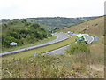
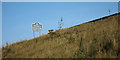
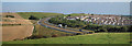
A sweep of the Shoreham bypass looking west
The county sign for West Sussex is opposite the Brighton and Hove sign on the eastbound carriageway and they appear to be more than a third of a mile east of the actual county boundary. See also
Image
Image: © Shazz
Taken: 19 Sep 2016
0.11 miles
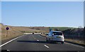
3
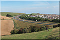
Brighton By-Pass
Built in the 1990s to alleviate the congestion the old route of the A27 caused as it travelled through the conurbation. The section between the Hangelton and Holmbush Interchanges was the last to be completed. The eastbound carriageway is in this square whereas the westbound one is in TQ2407 along with Mile Oak. Foredown Hill is in the distance.
Image: © Simon Carey
Taken: 2 Dec 2010
0.13 miles
4
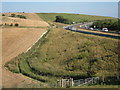
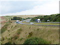
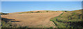
Cockroost Bottom
Looking towards the A27 from near the Cockroost Hill reservoir.
Image: © Oast House Archive
Taken: 1 Sep 2011
0.13 miles
5
Welcome to Brighton and Hove
Sign beside the A27 Shoreham Bypass.
Image: © Oast House Archive
Taken: 1 Sep 2011
0.13 miles
6
Cockroost Bottom
Looking towards the A27 from near the Cockroost Hill reservoir.
Image: © Oast House Archive
Taken: 1 Sep 2011
0.14 miles
7
A sweep of the Shoreham bypass looking east
The sign for Brighton and Hove is close to the roadside parking area. See comment at Image
Image: © Shazz
Taken: 19 Sep 2016
0.14 miles
8
Cockroost Bottom
The embankment to the right is the A27 road.
Image: © Oast House Archive
Taken: 1 Sep 2011
0.15 miles
9
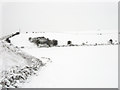
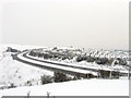
Monarch's Way
The long distance footpath runs along Cockroost Bottom before ascending Cockroost Hill running next to the embankment of the A27. The snow is knee deep in places here.
Image: © Simon Carey
Taken: 2 Dec 2010
0.15 miles
10
A27 past Mile Oak
Looking from near the Cockroost Hill reservoir.
Image: © Oast House Archive
Taken: 1 Sep 2011
0.16 miles