IMAGES TAKEN NEAR TO
Vale Road, BRIGHTON, BN41 1GG
Introduction
This page details the photographs taken nearby to Vale Road, BN41 1GG by members of the Geograph project.
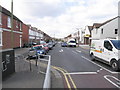
The Geograph project started in 2005 with the aim of publishing, organising and preserving representative images for every square kilometre of Great Britain, Ireland and the Isle of Man.

There are currently over 7.5m images from over14,400 individuals and you can help contribute to the project by visiting https://www.geograph.org.uk
Image Map
Images are licensed for reuse under creativecommons.org/licenses/by-sa/2.0
Notes
- Clicking on the map will re-center to the selected point.
- The higher the marker number, the further away the image location is from the centre of the postcode.
Image Listing (68 Images Found)
Images are licensed for reuse under creativecommons.org/licenses/by-sa/2.0
Image
Details
Distance
2
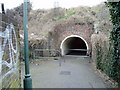
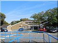
Public footpath in subway under West Coastway line
Route to Old Shoreham Road.
Image: © Peter Holmes
Taken: 17 Mar 2012
0.09 miles
3
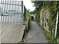
Portslade-by-Sea, tunnel
Under railway lines, on the footpath from Shoreham Old Road to Boundary Road.
Image: © Mike Faherty
Taken: 11 Aug 2018
0.10 miles
4
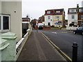
Footpath on Gordon Road
Approaching junction with Vale Road.
Image: © Peter Holmes
Taken: 17 Mar 2012
0.11 miles
6
Portslade Health Centre
located in Church Road http://www.portsladehealthcentre.co.uk/
Image: © Paul Gillett
Taken: 24 Sep 2013
0.12 miles